
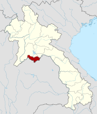
Vientiane prefecture
| Vientiane | |
|---|---|
| Capital: | Vientiane |
| Surface: | 3,920 km² |
| Residents: | 820,940 (2015 census) |
| Inhabitants per km²: | 209 per km² |
| map | |
  |
|
The prefecture of Vientiane ( Lao ນະ ຄອນ ຫຼວງ ວຽງ ຈັນ , Nakhon Luang Vieng Chan ) is an administrative unit in the northwest of Laos . The capital of the prefecture is also the state capital: Vientiane .
history
In 1989 the province of Vientiane was split into two parts, the prefecture of Vientiane, which included the capital Vientiane, and the rest of the area, the province of Vientiane .
geography
The prefecture of Vientiane is located in the northwest of the country. The neighboring provinces are (clockwise from west): Vientiane (province) , Saysomboun and Bolikhamsai .
To the south, the Mekong forms the border to Thailand . On the opposite bank lies the Thai province of Nong Khai .
traffic
In the prefecture is the First Thai-Lao Friendship Bridge with the border crossing to Thailand as well as the Nong Khai – Thanaleng railway and the Thanaleng train station . In addition, the AH12 trunk road of the Asian trunk road project leading to Bangkok is located here .
Administrative division
The prefecture consists of the following nine districts ( ເມືອງ - [ mʉ̄aṅ ]):
| code | District | Lao | |
|---|---|---|---|

|
|||
| 01-01 | Chanthabuly | ຈັນ ທະ ບູ ລີ | |
| 01-02 | Sikhottabong | ສີ ໂຄດ ຕະ ບອງ | |
| 01-03 | Xaysetha | ໄຊ ເສດ ຖາ | |
| 01-04 | Sisattanak | ສີ ສັດ ຕະ ນາກ | |
| 01-05 | Naxaithong | ນາ ຊາຍ ທອງ | |
| 01-06 | Xaythany | ໄຊ ທາ ນີ | |
| 01-07 | Hadxayfong | ຫາດ ຊາຍ ຟອງ | |
| 01-08 | Sangthong | ສັງ ທອງ | |
| 01-09 | Mayparkngum | ໃໝ່ ປາກ ງື່ມ |
Note: The districts in bold are part of the city of Vientiane, officially called "Vientiane Capital".
Provinces: Attapeu | Bokeo | Bolikhamsai | Champasak | Houaphan | Khammuan | Luang Namtha | Luang Prabang | Oudomxay | Phongsali | Sainyabuli | Salavan | Savannakhet | Saysomboun | Sekong | Vientiane | Xieng Khouang
Prefecture: Vientiane