
Luang Prabang Province
| ຫລວງ ພະ ບາງ Luang Prabang
|
|
|---|---|
  |
|
| Basic data | |
| Country | Laos |
| Capital | Luang Prabang |
| surface | 16,875 km² |
| Residents | 431,889 (2015 census) |
| density | 26 inhabitants per km² |
| ISO 3166-2 | LA-LP |
 |
|
Coordinates: 20 ° 12 ' N , 102 ° 36' E
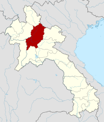
Luang Prabang ( Lao ຫລວງ ພະ ບາງ , ALA-LC : Lūang Phabāng ) is a province ( Khwaeng ) in northern Laos . The capital of the province is the city of the same name, Luang Prabang .
geography
Neighboring provinces (from the north counter-clockwise): Phongsali , Oudomxay , Sayaburi , Vientiane , Saysomboun , Xieng Khouang and Houaphan . In the northeast, Luang Prabang borders the Điện Biên province of Vietnam .
traffic
The province has an international airport in the provincial capital Luang Prabang, Luang Prabang Airport ( IATA : LPQ, ICAO : VLLB).
Luang Prabang is connected to Vang Vieng and Vientiane by National Road 13, and Muang Xay by National Road 1. National Road 13 continues down to Cambodia.
The Mekong also offers an important transport link. Huay Xai upstream on the Thai border (opposite the Thai district of Chiang Khong ) can be reached, for example, from the provincial capital by slow boat in two days, with a stopover in Pakbeng (Oudomxay province).
Administrative units
The province consists of the following districts:
| code | District | Lao |
|---|---|---|

|
||
| 06-01 | Luangprabang | ເມືອງ ຫຼວງ ພະ ບາງ ຫຼວງ ພະ ບາງ |
| 06-02 | Xieng ngeun | ຊຽງ ເງິນ |
| 06-03 | Nan | ນານ |
| 06-04 | Pak Ou | ປາກ ອູ |
| 06-05 | Nambak | ນ ້ ຳ ບາກ |
| 06-06 | Ngoi | ງອຍ |
| 06-07 | Pak Xeng | ປາກ ແຊງ |
| 06-08 | Phonxay | ໂພນ ໄຊ |
| 06-09 | Chomphet | ຈອມ ເພັດ |
| 06-10 | Viengkham | ວຽງ ຄຳ |
| 06-11 | Phoukhoune | ພູ ຄູນ |
| 06-12 | Phonthong | ເມືອງ ໂພນ ທອງ |
Web links
- http://www.luangprabang.gov.la/ Provincial administration website
Provinces: Attapeu | Bokeo | Bolikhamsai | Champasak | Houaphan | Khammuan | Luang Namtha | Luang Prabang | Oudomxay | Phongsali | Sainyabuli | Salavan | Savannakhet | Saysomboun | Sekong | Vientiane | Xieng Khouang
Prefecture: Vientiane