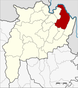
Chiang Khong district
|
Chiang Khong เชียงของ |
|
|---|---|
| Province: | Chiang Rai |
| Surface: | 836.9 km² |
| Residents: | 62,605 (2013) |
| Population density : | 76.1 U / km² |
| ZIP : | 57140 |
| Geocode : | 5703 |
| map | |

|
|
Amphoe Chiang Khong (in Thai : อำเภอ เชียงของ , pronunciation: ʔāmpʰɤ̄ː tɕʰīaŋ kʰɔ̌ːŋ ) is a district ( Amphoe - administrative district) in the northeast of Chiang Rai Province . Chiang Rai Province is located in the far north of the northern region of Thailand .
geography
Neighboring Thai counties are (called clockwise from the southeast) the Amphoe Wiang Kaen , Khun Tan , Phaya Mengrai , Wiang Chiang Rung , Doi Luang , Chiang Saen . The most important river in the district is the Mekong , which forms the border with Laos here. The Laotian province of Bokeo lies on the northeastern bank . Opposite the main town Wiang Chiang Khong is its capital Ban Houayxay ; Since December 2013, both places have been connected by the Fourth Thai-Lao Friendship Bridge , which is close to the south .
administration
Provincial Administration
Chiang Khong County is divided into seven tambon ("subdistricts" or "parishes"), which are further subdivided into 102 muban ("villages").
| No. | Surname | Thai | Muban | Pop. |
|---|---|---|---|---|
| 1. | Wiang | เวียง | 14th | 12,786 |
| 2. | Sathan | สถาน | 16 | 9,389 |
| 3. | Khrueng | ครึ่ง | 11 | 6,564 |
| 4th | Bun Rueang | บุญ เรือง | 10 | 6.339 |
| 5. | Huai So | ห้วย ซ้อ | 23 | 12,334 |
| 8th. | Si Don Chai | ศรี ดอน ชัย | 18th | 8,813 |
| 10. | Rim Khong | ริม โขง | 10 | 6,380 |
Note: The missing numbers refer to tambon, which now form the Wiang Kaen district.
Local administration
There are seven municipalities with "small town" status ( Thesaban Tambon ) in the district:
- Sathan (Thai: เทศบาล ตำบล สถาน ) consisting of the complete Tambon Sathan.
- Si Don Chai (Thai: เทศบาล ตำบล ศรี ดอน ชัย ) consisting of the complete Tambon Si Don Chai.
- Bun Rueang (Thai: เทศบาล ตำบล บุญ เรือง ) consisting of the complete Tambon Bun Rueang.
- Wiang Chiang Khong (Thai: เทศบาล ตำบล เวียง เชียงของ ) consisting of parts of the tambon Wiang.
- Wiang (Thai: เทศบาล ตำบล เวียง ) consisting of parts of the tambon Wiang.
- Khrueng (Thai: เทศบาล ตำบล ครึ่ง ) consisting of the complete tambon Khrueng.
- Huai So (Thai: เทศบาล ตำบล ห้วย ซ้อ ) consisting of the complete tambon Huai So.
There is also a " Tambon Administration Organization " ( องค์การ บริหาร ส่วน ตำบล - Tambon Administrative Organization, TAO)
- Rim Khong (Thai: องค์การ บริหาร ส่วน ตำบล ริม โขง ) consisting of the complete tambon Rim Khong.
Individual evidence
- ↑ 2013 population statistics ( Thai ) Department of Provincial Administration. Retrieved October 26, 2014.
Web links
Coordinates: 20 ° 15 ′ 40.5 ″ N , 100 ° 24 ′ 21.5 ″ E

