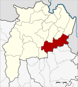
Amphoe Thoeng
|
Thoeng เทิง |
|
|---|---|
| Province: | Chiang Rai |
| Surface: | 821.0 km² |
| Residents: | 84,196 (2013) |
| Population density : | 102.9 U / km² |
| ZIP : | 57160, 57230 |
| Geocode : | 5704 |
| map | |

|
|

Amphoe Thoeng (in Thai : อำเภอ เทิง , pronunciation: ʔāmpʰɤ̄ː tʰɤ̄ːŋ ) is a district ( Amphoe - administrative district) of the Chiang Rai Province . Chiang Rai Province is located in the far north of the northern region of Thailand .
geography
Neighboring counties (from southwest clockwise): the Amphoe Pa Daet , Mueang Chiang Rai , Wiang Chai , Phaya Mengrai , Khun Tan and Wiang Kaen of the Chiang Rai Province. To the east of Thoeng lies the Laotian province of Sayaburi and to the south the Phu Sang , Chiang Kham and Chun districts of the Phayao province . Thoeng is a mountain country.
administration
Provincial Administration
The district of Thoeng is divided into ten tambon ("subdistricts" or "communities"), which are further subdivided into 154 muban ("villages").
| No. | Surname | Thai | Muban | Pop. |
|---|---|---|---|---|
| 1. | Wiang | เวียง | 25th | 16,703 |
| 2. | Ngio | งิ้ว | 25th | 12,051 |
| 3. | Plong | ปล้อง | 12 | 8,429 |
| 4th | Mae Loi | แม่ ลอย | 13 | 6,775 |
| 5. | Chiang Khian | เชียง เคี่ ย น | 12 | 4,424 |
| 9. | Tap Tao | ตับเต่า | 25th | 13,165 |
| 10. | Ngao | ห งาว | 20th | 9,559 |
| 11. | San Sai Ngam | สันทราย งาม | 5 | 4,268 |
| 12. | Si Don Chai | ศรี ดอน ไชย | 10 | 4,645 |
| 13. | Nong Raet | หนอง แรด | 7th | 4.177 |
The missing numbers refer to tambon, which now form the Khun Tan district.
Local administration
There are six municipalities with "small town" status ( Thesaban Tambon ) in the district:
- Ngio (Thai: เทศบาล ตำบล งิ้ว ) consisting of the complete Tambon Ngio.
- Chiang Khian (Thai: เทศบาล ตำบล เชียง เคี่ ย น ) consisting of the complete tambon Chiang Khian.
- Ngao (Thai: เทศบาล ตำบล ห งาว ) consisting of the complete Tambon Ngao.
- San Sai Ngam (Thai: เทศบาล ตำบล สันทราย งาม ) consisting of the complete Tambon San Sai Ngam.
- Ban Plong (Thai: เทศบาล ตำบล บ้าน ปล้อง ) consisting of parts of the Tambon Plong.
- Wiang Thoeng (Thai: เทศบาล ตำบล เวียง เทิง ) consisting of parts of the tambon Wiang.
In addition, there are six " tambon administration organizations " ( องค์การ บริหาร ส่วน ตำบล - Tambon Administrative Organizations, TAO)
- Wiang (Thai: องค์การ บริหาร ส่วน ตำบล เวียง ) consisting of parts of the tambon Wiang.
- Plong (Thai: องค์การ บริหาร ส่วน ตำบล ปล้อง ) consisting of parts of the tambon plong.
- Mae Loi (Thai: องค์การ บริหาร ส่วน ตำบล แม่ ลอย ) consisting of the complete Tambon Mae Loi.
- Tap Tao (Thai: องค์การ บริหาร ส่วน ตำบล ตับเต่า ) consisting of the complete tambon Tap Tao.
- Si Don Chai (Thai: องค์การ บริหาร ส่วน ตำบล ศรี ดอน ไชย ) consisting of the complete tambon Si Don Chai.
- Nong Raet (Thai: องค์การ บริหาร ส่วน ตำบล หนอง แรด ) consisting of the complete Tambon Nong Raet.
Individual evidence
- ↑ 2013 population statistics ( Thai ) Department of Provincial Administration. Retrieved October 26, 2014.
Web links
Coordinates: 19 ° 41 ′ N , 100 ° 12 ′ E
