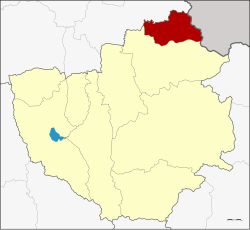
Phu Sang district
|
Phu Sang ภู ซาง |
|
|---|---|
| Province: | Phayao |
| Surface: | 293.486 km² |
| Residents: | 31,942 (2013) |
| Population density : | 107 U / km² |
| ZIP : | 56110 |
| Geocode : | 5608 |
| map | |

|
|

Amphoe Chun ( Thai : อำเภอ ภู ซาง ) is a district ( Amphoe - administrative district) in the north of Phayao Province . Phayao Province is located in the northeastern part of the northern region of Thailand .
geography
Phu Sang borders, clockwise from the south, with Amphoe Chiang Kham in Phayao Province and Amphoe Thoeng in Chiang Rai Province . The northeast of the district borders the Sainyabuli province of Laos .
history
Phu Sang was first established on June 26, 1996 as a "branch circle" ( King Amphoe ). It initially consisted of five tambon that previously belonged to the Amphoe Chiang Kham .
On May 15, 2007 the Thai government decided to raise all 81 King Amphoe to simple amphoe status in order to unify the administration. With the publication in the Royal Gazette "Issue 124 chapter 46" on August 24, 2007 this decision officially entered into force.
administration
Provincial Administration
Phu Sang County is divided into five tambon (“subdistricts” or “parishes”), which are further subdivided into 59 muban (“villages”).
| No. | Surname | Thai | Muban | Pop. |
|---|---|---|---|---|
| 1. | Phu Sang | ภู ซาง | 13 | 6.384 |
| 2. | Pa Sak | ป่า สัก | 10 | 4,207 |
| 3. | Thung Kluai | ทุ่ง กล้วย | 12 | 7,970 |
| 4th | Chiang Raeng | เชียง แรง | 12 | 5,866 |
| 5. | Sop bong | สบ บ ง | 12 | 7,515 |
Local administration
There is one municipality with "small town" status ( Thesaban Tambon ) in the district:
- Sop Bong (Thai: เทศบาล ตำบล สบ บ ง ) consisting of the complete Tambon Sop Bong.
There are also four " tambon administration organizations " ( องค์การ บริหาร ส่วน ตำบล - Tambon Administrative Organizations, TAO)
- Phu Sang (Thai: องค์การ บริหาร ส่วน ตำบล ภู ซาง ) consisting of the complete Tambon Phu Sang.
- Pa Sak (Thai: องค์การ บริหาร ส่วน ตำบล ป่า สัก ) consisting of the complete tambon Pa Sak.
- Thung Kluai (Thai: องค์การ บริหาร ส่วน ตำบล ทุ่ง กล้วย ) consisting of the complete tambon Thung Kluai.
- Chiang Raeng (Thai: องค์การ บริหาร ส่วน ตำบล เชียง แรง ) consisting of the complete tambon Chiang Raeng.
Individual evidence
- ↑ ประกาศ กระทรวง มหาดไทย เรื่อง แบ่ง เขต ท้องที่ อำเภอ เชียงคำ จังหวัด พะเยา ตั้ง เป็น กิ่ง อำเภอ ภู ซาง . In: Royal Gazette . 113, No. พิเศษ 18 ง (special), June 26, 1996, p. 28.
- ↑ www.manager.co.th
- ↑ พระราชกฤษฎีกา ตั้ง อำเภอ ฆ้องชัย ... และ อำเภอ เหล่า เสือ โก้ ก พ.ศ. ๒๕๕๐ Royal Gazette, Volume 124, Issue 46 ก August 24, 2007, pp. 14-21 (in Thai).
- ↑ 2013 population statistics ( Thai ) Department of Provincial Administration. Retrieved October 30, 2014.
Web links
Coordinates: 19 ° 36 ' N , 100 ° 19' E
