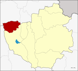
Mae Chai district
|
Mae Chai แม่ใจ |
|
|---|---|
| Province: | Phayao |
| Surface: | 300.8 km² |
| Residents: | 34,451 (2013) |
| Population density : | 124.6 U / km² |
| ZIP : | 56130 |
| Geocode : | 5607 |
| map | |

|
|

Amphoe Mae Chai ( Thai อำเภอ แม่ใจ ) is a district ( Amphoe - administrative district) in the west of Phayao Province . The Phayao Province is located in the northeastern part of the northern region of Thailand .
geography
Mae Chai District is located in the upper valley of the Ing River . To the west of the city of Mae Chai rise the Doi Luang Mountains, protected by the Doi Luang National Park. To the east is the Nong Leang Sai Reservoir, and on the border with the Mueang District, the Mae Pim Reservoir. Mae Puem National Park protects the Mae-Puem National Conserved Forest and the Dong Pra-Doo Forest .
Neighboring districts (from north clockwise): Amphoe Phan and Pa Daet the province of Chiang Rai , Amphoe Mueang Phayao Province Phayao and Amphoe Wang Nuea in the province of Lampang .
history
Mae Chai County was dissolved on December 23, 1917 and incorporated into Mueang Phan District . On January 24, 1963, it was set up again - initially as a "branch circle" ( King Amphoe ) . On July 28, 1965, Mae Chai got full amphoe status. In 1977 the district was assigned to the newly established Phayao Province by Chiang Rai Province.
administration
Provincial Administration
Mae Chai County is divided into six tambon ("subdistricts" or "parishes"), which are further subdivided into 66 muban ("villages").
| No. | Surname | Thai | Muban | Pop. |
|---|---|---|---|---|
| 1. | Mae Chai | แม่ใจ | 10 | 4,771 |
| 2. | Si Thoi | ศรี ถ้อย | 13 | 7,059 |
| 3. | Mae Suk | แม่ สุก | 10 | 5,510 |
| 4th | Pa Faek | ป่า แฝก | 11 | 5,240 |
| 5. | Ban Lao | บ้าน เหล่า | 14th | 7,956 |
| 6th | Charoen Council | เจริญ ราษฎร์ | 8th | 3,915 |
Local administration
There are six municipalities with "small town" status ( Thesaban Tambon ) in the district:
- Ruam Chai Phatthana (Thai: เทศบาล ตำบล รวมใจ พัฒนา ) consisting of parts of the Tambon Mae Chai.
- Si Thoi (Thai: เทศบาล ตำบล ศรี ถ้อย ) consisting of parts of the tambon Si Thoi.
- Pa Faek (Thai: เทศบาล ตำบล ป่า แฝก ) consisting of the complete tambon Pa Faek.
- Charoen Rat (Thai: เทศบาล ตำบล เจริญ ราษฎร์ ) consisting of the complete Tambon Charoen Rat.
- Mae Chai (Thai: เทศบาล ตำบล แม่ใจ ) consisting of the parts of the Tambon Mae Chai, Si Thoi.
- Ban Lao (Thai: เทศบาล ตำบล บ้าน เหล่า ) consisting of the complete tambon Ban Lao.
There is also a " tambon administration organizations " ( องค์การ บริหาร ส่วน ตำบล - Tambon Administrative Organizations, TAO)
- Mae Suk (Thai: องค์การ บริหาร ส่วน ตำบล แม่ สุก ) consisting of the complete Tambon Mae Suk.
Individual evidence
- ↑ ประกาศ กระทรวง มหาดไทย เรื่อง ให้ ยุบ อำเภอ แม่ใจ และ อำเภอ ดอกคำใต้ Royal Gazette, Vol. 34, Ed. 0 ก of December 23, 1917, p. 505 (in Thai)
- ↑ ประกาศ กระทรวง มหาดไทย เรื่อง แบ่ง ท้องที่ ตั้ง เป็น กิ่ง อำเภอ Royal Gazette, Vol. 80, Issue 14 ง of February 5, 1963, pp. 221–222 (in Thai)
- ↑ พระราชกฤษฎีกา ตั้ง อำเภอ ศรีสวัสดิ์ อำเภอ สังขละบุรี อำเภอ ท่าคันโท อำเภอ ดอกคำใต้ อำเภอ แม่ใจ อำเภอ จุน อำเภอ ขามทะเลสอ อำเภอ ไพศาลี อำเภอ ท่าวังผา อำเภอ บ้านกรวด อำเภอ เด่นชัย เด่นชัย อำเภอ ปทุมรัตต์ อำเภอ กะเปอร์ อำเภอ อากาศอำนวย อำเภอ ดอนเจดีย์ อำเภอ จอมพระ และ อำเภอ สามโก้ พ.ศ. ๒๕๐๘ Royal Gazette, Vol. 81, Issue 49 ก July 27, 1965, pp. 565–569 (in Thai)
- ↑ 2013 population statistics ( Thai ) Department of Provincial Administration. Retrieved October 30, 2014.
Web links
- More information about Amphoe Mae Chai from Amphoe.com (in Thai)
- Information from the park administration of Mae Puem National Park (in English)
Coordinates: 19 ° 21 ' N , 99 ° 49' E
