Chiang Kham district
|
Chiang Kham เชียงคำ |
|
|---|---|
| Province: | Phayao |
| Surface: | 784.061 km² |
| Residents: | 77,075 (2013) |
| Population density : | 98.5 U / km² |
| ZIP : | 56110 |
| Geocode : | 5603 |
| map | |

|
|

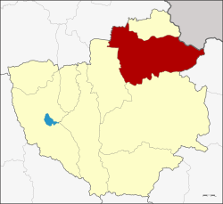
Amphoe Chiang Kham ( Thai อำเภอ เชียงคำ ) is a district ( Amphoe - Administrative District) in the northeast of the Phayao Province . Phayao Province is located in the northeastern part of the northern region of Thailand .
geography
Amphoe Chiang Kham borders, clockwise, from Amphoe Pong and Chun in Phayao Province, Amphoe Thoeng in Chiang Rai Province and Amphoe Phu Sang in Phayao. In the northeast lies the Sainyabuli province of Laos .
administration
Provincial Administration
Chiang Kham County is divided into ten tambon ("subdistricts" or "parishes"), which are further subdivided into 135 muban ("villages").
| No. | Surname | Thai | Muban | Pop. |
|---|---|---|---|---|
| 1. | yuan | หย่วน | 15th | 11,611 |
| 6th | Nam Waen | น้ำ แวน | 14th | 7,055 |
| 7th | Wiang | เวียง | 10 | 5,719 |
| 8th. | Fai Kwang | ฝาย กวาง | 17th | 8,874 |
| 9. | Chedi Kham | เจดีย์ คำ | 12 | 6,052 |
| 10. | Rome yen | ร่มเย็น | 22nd | 12,140 |
| 11. | Chiang Ban | เชียง บาน | 11 | 7,387 |
| 12. | Mae Lao | แม่ ลาว | 14th | 6,449 |
| 13. | Ang Thong | อ่างทอง | 13 | 8,351 |
| 14th | Thung Pha Suk | ทุ่ง ผาสุข | 7th | 3,437 |
Local administration
There are four municipalities with "small town" status ( Thesaban Tambon ) in the district:
- Yuan (Thai: เทศบาล ตำบล หย่วน ) consisting of parts of the Tambon Yuan.
- Chiang Kham (Thai: เทศบาล ตำบล เชียงคำ ) consisting of parts of the Tambon Yuan.
- Wiang (Thai: เทศบาล ตำบล เวียง ) consisting of the complete tambon Wiang.
- Fai Kwang (Thai: เทศบาล ตำบล ฝาย กวาง ) consisting of the complete Tambon Fai Kwang.
In addition, there are seven " Tambon Administration Organizations " ( องค์การ บริหาร ส่วน ตำบล - Tambon Administrative Organizations, TAO)
- Nam Waen (Thai: องค์การ บริหาร ส่วน ตำบล น้ำ แวน ) consisting of the complete tambon Nam Waen.
- Chedi Kham (Thai: องค์การ บริหาร ส่วน ตำบล เจดีย์ คำ ) consisting of the complete Tambon Chedi Kham.
- Rom Yen (Thai: องค์การ บริหาร ส่วน ตำบล ร่มเย็น ) consisting of the complete tambon Rom Yen.
- Chiang Ban (Thai: องค์การ บริหาร ส่วน ตำบล เชียง บาน ) consisting of the complete tambon Chiang Ban.
- Mae Lao (Thai: องค์การ บริหาร ส่วน ตำบล แม่ ลาว ) consisting of the complete tambon Mae Lao.
- Ang Thong (Thai: องค์การ บริหาร ส่วน ตำบล อ่างทอง ) consisting of the complete tambon Ang Thong.
- Thung Pha Suk (Thai: องค์การ บริหาร ส่วน ตำบล ทุ่ง ผาสุข ) consisting of the complete tambon Thung Pha Suk.
Individual evidence
- ↑ 2013 population statistics ( Thai ) Department of Provincial Administration. Retrieved October 30, 2014.
Web links
Coordinates: 19 ° 31 ' N , 100 ° 18' E
