Amphoe Pong
|
Pong ป ง |
|
|---|---|
| Province: | Phayao |
| Surface: | 1783., 452 km² |
| Residents: | 52,934 (2013) |
| Population density : | 29.8 U / km² |
| ZIP : | 56140 |
| Geocode : | 5606 |
| map | |

|
|

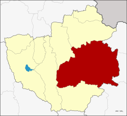
Amphoe Pong ( Thai อำเภอ ป ง ) is a district ( Amphoe - administrative district) in the east of Phayao Province . Phayao Province is located in the northeastern part of the northern region of Thailand .
geography
Pong district is bordered by the following counties (clockwise from the east): Song Khwae , Tha Wang Pha, and Mueang Nan district in Nan Province, and Chiang Muan , Dok Khamtai , Chun, and Chiang Kham district in Phayao Province.
history
The county was originally called Mueang Pong, but was renamed Ban Muang ( บ้านม่วง ) in 1917 . In 1939 it was renamed back to Pong, the term Mueang was omitted. In 1952 the district was assigned to Chiang Rai Province, with the exception of the Sa-iap sub-district, which was separated and subordinated to the Song District in Phrae . When the new Phayao Province was established in 1977, Pong was assigned to it.
administration
Provincial Administration
Pong County is divided into seven tambon ("subdistricts" or "parishes"), which are further subdivided into 88 muban ("villages").
| No. | Surname | Thai | Muban | Pop. |
|---|---|---|---|---|
| 1. | Pong | ป ง | 16 | 8,180 |
| 2. | Khuan | ควร | 11 | 5,490 |
| 3. | Oi | อ อย | 14th | 7,072 |
| 4th | Ngim | งิ ม | 19th | 11,953 |
| 5. | Pha Chang Noi | ผา ช้างน้อย | 7th | 5,150 |
| 6th | Well Prang | นาปรัง | 9 | 5,772 |
| 7th | Khun Khuan | ขุน ควร | 12 | 9,317 |
Local administration
There are three municipalities with "small town" status ( Thesaban Tambon ) in the district:
- Mae Yom (Thai: เทศบาล ตำบล แม่ ยม ) consisting of parts of the Tambon Pong.
- Ngim (Thai: เทศบาล ตำบล งิ ม ) consisting of parts of the Tambon Ngim.
- Pong (Thai: เทศบาล ตำบล ป ง ) consisting of the parts of the Tambon Pong, Na Prang.
In addition, there are six " tambon administration organizations " ( องค์การ บริหาร ส่วน ตำบล - Tambon Administrative Organizations, TAO)
- Khuan (Thai: องค์การ บริหาร ส่วน ตำบล ควร ) consisting of the complete tambon khuan.
- Oi (Thai: องค์การ บริหาร ส่วน ตำบล อ อย ) consisting of the complete Tambon Oi.
- Ngim (Thai: องค์การ บริหาร ส่วน ตำบล งิ ม ) consisting of parts of the Tambon Ngim.
- Pha Chang Noi (Thai: องค์การ บริหาร ส่วน ตำบล ผา ช้างน้อย ) consisting of the complete tambon Pha Chang Noi.
- Na Prang (Thai: องค์การ บริหาร ส่วน ตำบล นาปรัง ) consisting of parts of the Tambon Na Prang.
- Khun Khuan (Thai: องค์การ บริหาร ส่วน ตำบล ขุน ควร ) consisting of the complete tambon Khun Khuan.
Individual evidence
- ↑ ประกาศ กระทรวง มหาดไทย เรื่อง เปลี่ยน ชื่อ อำเภอ . In: Royal Gazette . 34, No. 0 ก , April 29, 1917, pp. 40-68.
- ↑ พระราชกฤษฎีกา เปลี่ยน นาม อำเภอ กิ่ง อำเภอ และ ตำบล บาง แห่ง พุทธศักราช ๒๔๘๒ . In: Royal Gazette . 56, No. 0 ก , April 17, 1939, pp. 354-364.
- ↑ พระราชบัญญัติ เปลี่ยนแปลง เขต จังหวัด น่าน จังหวัด เชียงราย และ จังหวัด แพร่ พ.ศ. ๒๔๙๕ . In: Royal Gazette . 69, No. 77 ก , December 30, 1952, pp. 1440-1441.
- ↑ 2013 population statistics ( Thai ) Department of Provincial Administration. Retrieved October 30, 2014.
Web links
Coordinates: 19 ° 9 ′ N , 100 ° 17 ′ E
