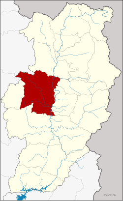
Mueang Nan district
|
Mueang Nan เมือง น่าน |
|
|---|---|
| Province: | Nan |
| Surface: | 813.1 km² |
| Residents: | 81,778 (2013) |
| Population density : | 99.8 U / km² |
| ZIP : | 55000 |
| Geocode : | 5501 |
| map | |

|
|

Amphoe Mueang Nan ( Thai : อำเภอ เมือง น่าน ) is a county ( amphoe - administrative district) in Nan Province . Nan Province is located in the northern region of Thailand .
geography
Neighboring districts are (from north clockwise): Amphoe Tha Wang Pha , Santi Suk , Phu Phiang , Wiang Sa and Ban Luang in Nan Province and Amphoe Pong the province of Phayao .
history
The history of the district goes back to Khwaeng Nakhon Nan, which was established in 1899 by the Ministry of the Interior. In 1917 it was renamed Mueang Nan.
administration
Provincial Administration
Mueang Nan County is divided into eleven tambon ("subdistricts" or "communities"), which are further subdivided into 109 Muban ("villages").
| No. | Surname | Thai | Muban | Pop. |
|---|---|---|---|---|
| 1. | Nai Wiang | ใน เวียง | - | 19,189 |
| 2. | Bo | บ่อ | 10 | 4,411 |
| 3. | Pha Sing | ผา สิงห์ | 9 | 6,391 |
| 4th | Chai Sathan | ไชย สถาน | 11 | 7.233 |
| 5. | Thuem Tong | ถื ม ตอง | 8th | 3,413 |
| 6th | Rueang | เรือง | 8th | 4,897 |
| 7th | Well Sao | นาซา ว | 7th | 3,595 |
| 8th. | You tai | ดู่ ใต้ | 15th | 8,458 |
| 9. | Kong Khwai | กอง ควาย | 12 | 5,464 |
| 16. | Bo Suak | บ่อ สวก | 13 | 6,572 |
| 17th | Sanian | สะ เนียน | 16 | 12,155 |
The missing geocodes refer to the tambon , which today belong to the Phu Phiang district.
Local administration
There is one commune with "city" status ( Thesaban Mueang ) in the district:
- Nan (Thai: เทศบาล เมือง น่าน ) consisting of the complete Tambon Nai Wiang and parts of the Tambon Pha Sing.
There are two municipalities with "small town" status ( Thesaban Tambon ) in the district:
- Du Tai (Thai: เทศบาล ตำบล ดู่ ใต้ ) consisting of the complete tambon Du Tai.
- Kong Khwai (Thai: เทศบาล ตำบล กอง ควาย ) consisting of the complete tambon Kong Khwai.
In addition, there are eight " tambon administration organizations " ( องค์การ บริหาร ส่วน ตำบล - Tambon Administrative Organizations, TAO)
- Bo (Thai: องค์การ บริหาร ส่วน ตำบล บ่อ ) consisting of the complete tambon Bo.
- Pha Sing (Thai: องค์การ บริหาร ส่วน ตำบล ผา สิงห์ ) consisting of parts of the Tambon Pha Sing.
- Chaiya Sathan (Thai: องค์การ บริหาร ส่วน ตำบล ไชย สถาน ) consisting of the complete tambon Chaiya Sathan.
- Thuem Tong (Thai: องค์การ บริหาร ส่วน ตำบล ถื ม ตอง ) consisting of the complete tambon Thuem Tong.
- Rueang (Thai: องค์การ บริหาร ส่วน ตำบล เรือง ) consisting of the complete tambon Rueang.
- Na Sao (Thai: องค์การ บริหาร ส่วน ตำบล นาซา ว ) consisting of the complete Tambon Na Sao.
- Bo Suak (Thai: องค์การ บริหารส่วน ตำบล บ่อ สวก ) consisting of the complete tambon Bo Suak.
- Sanian (Thai: องค์การ บริหารส่วน ตำบล สะ เนียน ) consisting of the complete Tambon Sanian.
Individual evidence
- ↑ ประกาศ กระทรวง มหาดไทย เรื่อง เปลี่ยน ชื่อ อำเภอ . In: Royal Gazette . 34, No. 0 ก , April 19, 1917, pp. 40-68.
- ↑ 2013 population statistics ( Thai ) Department of Provincial Administration. Retrieved October 29, 2014.
Web links
Coordinates: 18 ° 47 ' N , 100 ° 47' E

