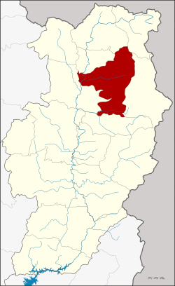
Amphoe Pua
|
Pua ปัว |
|
|---|---|
| Province: | Nan |
| Surface: | 657,363 km² |
| Residents: | 64,551 (2013) |
| Population density : | 97.4 U / km² |
| ZIP : | 55120 |
| Geocode : | 5505 |
| map | |

|
|

Amphoe Pua ( Thai อำเภอ ปัว ) is a district ( Amphoe - Administrative District) of Nan Province . Nan Province is located in the northeast of the northern region of Thailand .
geography
Neighboring counties (clockwise from north): the Amphoe Chiang Klang , Thung Chang , Chaloem Phra Kiat , Bo Kluea , Santi Suk and Tha Wang Pha . All of the Amphoe are in Nan Province.
Attractions
-
National parks :
- Doi Phu Kha National Park ( อุทยานแห่งชาติ ดอย ภู คา ) - mountainous park with the 1980 meter high Doi Phu Kha as the highest point. The numerous waterfalls are worth seeing.
- There are a number of Buddhist temples ( Wat ) in the district that are worth seeing , such as Wat Ton Laeng ( วัด ต้น แห ลง ), Wat Phrathat Bueng Sakat ( วัด พระ ธาตุ บึง สกัด ) or Wat Rong Ngae ( วัด ร้อง แง ).
administration
Provincial Administration
The district of Pua is divided into twelve tambon ("subdistricts" or "municipalities"), which are further subdivided into 107 Muban ("villages").
| No. | Surname | Thai | Muban | Pop. |
|---|---|---|---|---|
| 1. | Pua | ปัว | 8th | 7,362 |
| 2. | Ngaeng | แง ง | 7th | 4,848 |
| 3. | Sathan | สถาน | 13 | 6,064 |
| 4th | Sila Laeng | ศิลาแลง | 8th | 3,963 |
| 5. | Sila Phet | ศิลา เพชร | 10 | 4,593 |
| 6th | Uan | อ วน | 11 | 5,041 |
| 9. | Chai Watthana | ไชย วัฒนา | 8th | 4.233 |
| 10. | Chedi Chai | เจดีย์ ชัย | 9 | 6,913 |
| 11. | Phu Kha | ภู คา | 14th | 4,823 |
| 12. | Sakat | ส กาด | 4th | 2,932 |
| 13. | Pa sound | ป่า กลาง | 7th | 7,908 |
| 14th | Wora Nakhon | วร นคร | 8th | 5,871 |
Note: The missing geocodes belong to the tambon that are now part of the Bo Kluea district .
Local administration
There are two municipalities with "small town" status ( Thesaban Tambon ) in the district:
- Sila Laeng (Thai: เทศบาล ตำบล ศิลาแลง ) consisting of the complete tambon Sila Laeng.
- Pua (Thai: เทศบาล ตำบล ปัว ) consisting of the complete Tambon Pua and parts of the Tambon Sathan, Chai Watthana, Wora Nakhon.
In addition, there are ten " tambon administration organizations " ( องค์การ บริหาร ส่วน ตำบล - Tambon Administrative Organizations, TAO)
- Ngaeng (Thai: องค์การ บริหาร ส่วน ตำบล แง ง ) consisting of the complete Tambon Ngaeng.
- Sathan (Thai: องค์การ บริหาร ส่วน ตำบล สถาน ) consisting of parts of the Tambon Sathan.
- Sila Phet (Thai: องค์การ บริหาร ส่วน ตำบล ศิลา เพชร ) consisting of the complete Tambon Sila Phet.
- Uan (Thai: องค์การ บริหาร ส่วน ตำบล อ วน ) consisting of the complete tambon Uan.
- Chai Watthana (Thai: องค์การ บริหาร ส่วน ตำบล ไชย วัฒนา ) consisting of parts of the Tambon Chai Watthana.
- Chedi Chai (Thai: องค์การ บริหาร ส่วน ตำบล เจดีย์ ชัย ) consisting of the complete Tambon Chedi Chai.
- Phu Kha (Thai: องค์การ บริหาร ส่วน ตำบล ภู คา ) consisting of the complete Tambon Phu Kha.
- Sakat (Thai: องค์การ บริหารส่วน ตำบล ส กาด ) consisting of the complete tambon Sakat.
- Pa Klang (Thai: องค์การ บริหาร ส่วน ตำบล ป่า กลาง ) consisting of the complete Tambon Pa Klang.
- Wora Nakhon (Thai: องค์การ บริหาร ส่วน ตำบล วร นคร ) consisting of parts of the tambon Wora Nakhon.
Individual evidence
- ↑ 2013 population statistics ( Thai ) Department of Provincial Administration. Retrieved October 29, 2014.
Web links
- More details on Amphoe Pua from amphoe.com (in Thai)
- Description of Doi Phu Kha National Park (in English)
Coordinates: 19 ° 10 ′ N , 100 ° 55 ′ E


