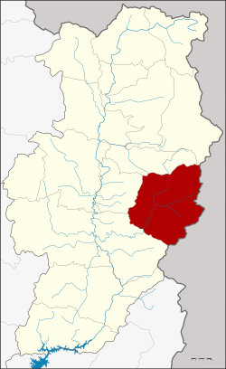
Mae Charim district
|
Mae Charim แม่จริม |
|
|---|---|
| Province: | Nan |
| Surface: | 998.152 km² |
| Residents: | 15,989 (2013) |
| Population density : | 15.8 U / km² |
| ZIP : | 55170 |
| Geocode : | 5502 |
| map | |

|
|

Amphoe Mae Charim ( Thai : อำเภอ แม่จริม ) is a district ( Amphoe - administrative district) in the east of Nan Province . Nan Province is located in the northeast of the northern region of Thailand .
geography
Neighboring counties (clockwise from southwest): Wiang Sa , Phu Phiang , Santi Suk and Bo Kluea districts of Nan Province. To the east lies the Sayaburi province of Laos .
history
Mae Charim was originally called Bowa ( บ่อ ว้า ). The "Branch Circle" ( King Amphoe ) Mae Charim was established on October 1, 1969, when the three Tambon Phong, Nong Daeng and Mo Mueang were separated from the Amphoe Mueang Nan . On April 12, 1977, Mae Charim was promoted to Amphoe.
Attractions
-
National parks :
- Mae Charim National Park (Thai: อุทยานแห่งชาติ แม่จริม ) - the 432 km² park is located in the mountains that separate Thailand from Laos. The highest point is the Doi Khun-Lan ( ดอย ขุน ลาน ) with 1652 meters height, on the slopes of which the Maenam Wa (Wa River) rises. Whitewater rafting is organized for tourists on the Wa River .
administration
Provincial Administration
Mae Charim County is divided into five tambon (“subdistricts” or “parishes”), which are further subdivided into 38 muban (“villages”).
| No. | Surname | Thai | Muban | Pop. |
|---|---|---|---|---|
| 2. | Nong Daeng | หนอง แดง | 10 | 4.152 |
| 3. | Mo Mueang | หมอ เมือง | 6th | 2,426 |
| 4th | Nam Phang | น้ำ พา ง | 10 | 5,127 |
| 5. | Nam Pai | น้ำ ปาย | 6th | 2,058 |
| 6th | Mae Charim | แม่จริม | 6th | 2,226 |
Note: The missing number 1 belongs to the Tambon Phong, which is now Teol from Santi Suk.
Local administration
There is one municipality with "small town" status ( Thesaban Tambon ) in the district:
- Nong Daeng (Thai: เทศบาล ตำบล หนอง แดง ) consisting of the parts of the Tambon Nong Daeng, Nam Pai.
There are also four " tambon administration organizations " ( องค์การ บริหาร ส่วน ตำบล - Tambon Administrative Organizations, TAO)
- Nong Daeng (Thai: องค์การ บริหาร ส่วน ตำบล หนอง แดง ) consisting of parts of the Tambon Nong Daeng.
- Mo Mueang (Thai: องค์การ บริหาร ส่วน ตำบล หมอ เมือง ) consisting of the complete tambon Mo Mueang and parts of the tambon Nam Pai.
- Nam Phang (Thai: องค์การ บริหาร ส่วน ตำบล น้ำ พา ง ) consisting of the complete Tambon Nam Phang.
- Mae Charim (Thai: องค์การ บริหาร ส่วน ตำบล แม่จริม ) consisting of the complete tambon Mae Charim.
Individual evidence
- ↑ ประกาศ กระทรวง มหาดไทย เรื่อง แบ่ง ท้องที่ ตั้ง เป็น กิ่ง อำเภอ . In: Royal Gazette . 86, No. 83 ง ฉบับ พิเศษ (special), September 24 1969, p. 10.
- ↑ พระราชกฤษฎีกา ตั้ง อำเภอ ปลายพระยา อำเภอ ห้วยเม็ก อำเภอ ละแม อำเภอ แม่จริม อำเภอ หนองกี่ อำเภอ โคกปีบ อำเภอ เกาะพะงัน อำเภอ สนม อำเภอ โซ่พิสัย อำเภอ โนนสะอาด และ อำเภอ นาจะหลวย พ.ศ. ๒๕๒๐ . In: Royal Gazette . 94, No. 31 ก , April 12 1977, pp. 326-330.
- ↑ 2013 population statistics ( Thai ) Department of Provincial Administration. Retrieved October 29, 2014.
Web links
- More details about Amphoe Mae Charim from amphoe.com (in Thai)
- Description of the Mae Charim National Park (in English)
Coordinates: 18 ° 42 ' N , 101 ° 0' E
