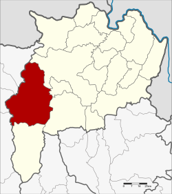
Mae Suai district
|
Mae Suai แม่สรวย |
|
|---|---|
| Province: | Chiang Rai |
| Surface: | 1,428.61 km² |
| Residents: | 80,222 (2013) |
| Population density : | 56.3 U / km² |
| ZIP : | 57180 |
| Geocode : | 5710 |
| map | |

|
|
Amphoe Mae Suai (in Thai : อำเภอ แม่สรวย , pronunciation: ʔāmpʰɤ̄ː mɛ̂ː sǔaj ) is a district ( Amphoe - administrative district) in the west of Chiang Rai Province . Chiang Rai Province is located in the far north of the northern region of Thailand .
geography
Neighboring counties (clockwise from northeast): the Amphoe Mueang Chiang Rai , Mae Lao , Phan and Wiang Pa Pao of Chiang Rai Province, and Phrao , Chai Prakan , Fang and Mae Ai of Chiang Mai Province .
administration
Provincial Administration
Mae Suai County is divided into seven tambon ("subdistricts" or "parishes"), which are further divided into 128 muban ("villages").
| No. | Surname | Thai | Muban | Pop. |
|---|---|---|---|---|
| 1. | Mae Suai | แม่สรวย | 17th | 8,920 |
| 2. | Pa Daet | ป่าแดด | 22nd | 11,188 |
| 3. | Mae Phrik | แม่พริก | 13 | 5,742 |
| 4th | Si Thoi | ศรี ถ้อย | 12 | 6,242 |
| 5. | Tha Ko | ท่า ก๊อ | 27 | 17,754 |
| 6th | Wawi | วา วี | 25th | 23,186 |
| 7th | Chedi Luang | เจดีย์ หลวง | 12 | 7.190 |
Local administration
There are three municipalities with "small town" status ( Thesaban Tambon ) in the district:
- Wiang Suai (Thai: เทศบาล ตำบล เวียง ส รวย ) consisting of parts of the Tambon Mae Suai.
- Mae Suai (Thai: เทศบาล ตำบล แม่สรวย ) consisting of parts of the Tambon Mae Suai.
- Chedi Luang (Thai: เทศบาล ตำบล เจดีย์ หลวง ) consisting of parts of the Tambon Chedi Luang.
In addition, there are six " tambon administration organizations " ( องค์การ บริหาร ส่วน ตำบล - Tambon Administrative Organizations, TAO)
- Pa Daet (Thai: องค์การ บริหาร ส่วน ตำบล ป่าแดด ) consisting of the complete Tambon Pa Daet.
- Mae Phrik (Thai: องค์การ บริหาร ส่วน ตำบล แม่พริก ) consisting of the complete tambon Mae Phrik.
- Si Thoi (Thai: องค์การ บริหาร ส่วน ตำบล ศรี ถ้อย ) consisting of the complete tambon Si Thoi.
- Tha Ko (Thai: องค์การ บริหาร ส่วน ตำบล ท่า ก๊อ ) consisting of the complete Tambon Tha Ko.
- Wawi (Thai: องค์การ บริหารส่วน ตำบล วา วี ) consisting of the complete Tambon Wawi.
- Chedi Luang (Thai: องค์การ บริหาร ส่วน ตำบล เจดีย์ หลวง ) consisting of parts of the Tambon Chedi Luang.
Individual evidence
- ↑ 2013 population statistics ( Thai ) Department of Provincial Administration. Retrieved October 26, 2014.
Web links
Coordinates: 19 ° 39 ' N , 99 ° 33' E

