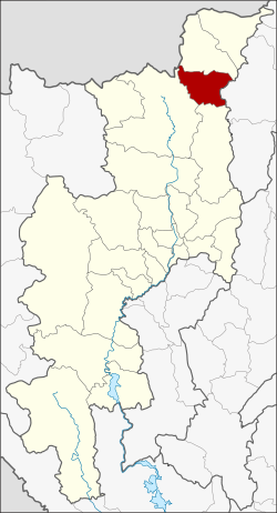
Chai Prakan district
|
Chai Prakan ไชย ปราการ |
|
|---|---|
| Province: | Chiang Mai |
| Surface: | 510.9 km² |
| Residents: | 44,670 (2013) |
| Population density : | 93.8 U / km² |
| ZIP : | 50320 |
| Geocode : | 5021 |
| map | |

|
|
Amphoe Chai Prakan (in Thai : อำเภอ ไชย ปราการ ) is a district ( Amphoe - administrative district) in the northeast of Chiang Mai Province . Chiang Mai Province is located in the northern region of Thailand .
geography
Neighboring counties (clockwise from the south): the Amphoe Phrao , Chiang Dao and Fang of Chiang Mai Province, and Mae Suai of Chiang Rai Province .
history
Chai Prakan was founded on January 1, 1988 as a "branch circle " ( King Amphoe ) , consisting of four tambon that were split off from the district of Fang . On July 4, 1994, Chai Prakan received full Amphoe status.
administration
Provincial Administration
The district of Chai Prakan is divided into four tambon ("subdistricts" or "parishes"), which are further subdivided into 44 muban ("villages").
| No. | Surname | Thai | Muban | Pop. |
|---|---|---|---|---|
| 1. | Pong Tam | ป ง ตำ | 8th | 8,055 |
| 2. | Si Dong Yen | ศรี ดง เย็น | 18th | 15,297 |
| 3. | Mae Thalop | แม่ทะ ลบ | 7th | 7,298 |
| 4th | Nong Bua | หนองบัว | 11 | 14,020 |
Local administration
There are two municipalities with "small town" status ( Thesaban Tambon ) in the district:
- Nong Bua (Thai: เทศบาล ตำบล หนองบัว ) consisting of parts of the Tambon Nong Bua.
- Chai Prakan (Thai: เทศบาล ตำบล ไชย ปราการ ) consisting of the complete Tambon Pong Tam and the parts of the Tambon Si Dong Yen, Nong Bua.
There are also two " tambon administration organizations " ( องค์การ บริหาร ส่วน ตำบล - Tambon Administrative Organizations, TAO)
- Si Dong Yen (Thai: องค์การ บริหาร ส่วน ตำบล ศรี ดง เย็น ) consisting of parts of the tambon Si Dong Yen.
- Mae Thalop (Thai: องค์การ บริหาร ส่วน ตำบล แม่ทะ ลบ ) consisting of the complete Tambon Mae Thalop.
Individual evidence
- ↑ ประกาศ กระทรวง มหาดไทย เรื่อง แบ่ง เขต ท้องที่ อำเภอ ฝาง จังหวัด เชียงใหม่ ตั้ง เป็น กิ่ง อำเภอ ไชย ปราการ Royal Gazette Volume 105, Ed. 5 ง of January 7, 1988, p. 107 (in Thai)
- ↑ พระราชกฤษฎีกา ตั้ง อำเภอ เปือยน้อย ... และ อำเภอ ศรีวิไล พ.ศ. ๒๕๓๗ Royal Gazette Volume 111, Ed. 21 ก June 3, 1994, pp. 32–35 (in Thai)
- ↑ 2013 population statistics ( Thai ) Department of Provincial Administration. Retrieved October 25, 2014.
Web links
Coordinates: 19 ° 44 ' N , 99 ° 8' E
