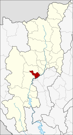
Doi Lo district
|
Doi Lo ดอย หล่อ |
|
|---|---|
| Province: | Chiang Mai |
| Surface: | 260.1 km² |
| Residents: | 26,196 (2013) |
| Population density : | 106.2 U / km² |
| ZIP : | 50160 |
| Geocode : | 5024 |
| map | |

|
|
Amphoe Doi Lo (in Thai : อำเภอ ดอย หล่อ ) is a district ( Amphoe - administrative district) of the Chiang Mai Province . Chiang Mai Province is located in the northern region of Thailand .
geography
Neighboring districts are (from the southwest clockwise): Amphoe Chom Thong , Mae Wang and San Pa Tong Chiang Mai province, and Pa Sang and Wiang Nong Long the province of Lamphun .
history
Doi Lo was founded on April 1, 1995 as a “branch circle” ( King Amphoe ) , consisting of four tambon that were split off from the Chom Thong district. The Thai government decided on May 15, 2007 that all sub-districts should be granted full Amphoe status. This decision became official on August 24, 2007 when it was published in the Royal Gazette.
administration
Provincial Administration
Doi Lo County is divided into four tambon ("subdistricts" or "municipalities"), which are further subdivided into 54 Muban ("villages").
| No. | Surname | Thai | Muban | Pop. |
|---|---|---|---|---|
| 1. | Doi Lo | ดอย หล่อ | 26th | 12,243 |
| 2. | Song Khwae | สอง แคว | 8th | 5,042 |
| 3. | Yang Khram | ยาง คราม | 11 | 4,985 |
| 4th | Santi Suk | สันติสุข | 9 | 3,926 |
Local administration
There are three municipalities with "small town" status ( Thesaban Tambon ) in the district:
- Song Khwae (Thai: เทศบาล ตำบล สอง แคว ) consisting of the complete tambon Song Khwae.
- Yang Khram (Thai: เทศบาล ตำบล ยาง คราม ) consisting of the complete tambon Yang Khram.
- Santi Suk (Thai: เทศบาล ตำบล สันติสุข ) consisting of the complete tambon Santi Suk.
There is also a " tambon administration organizations " ( องค์การ บริหาร ส่วน ตำบล - Tambon Administrative Organizations, TAO)
- Doi Lo (Thai: องค์การ บริหาร ส่วน ตำบล ดอย หล่อ ) consisting of the complete tambon Doi Lo.
Individual evidence
- ↑ ประกาศ กระทรวง มหาดไทย เรื่อง แบ่ง เขต ท้องที่ อำเภอ จอมทอง จังหวัด เชียงใหม่ ตั้ง เป็น กิ่ง อำเภอ ดอย หล่อ . In: Royal Gazette . 112, No. 9 ง พิเศษ (special), March 22, 2007, p. 65.
- ↑ แถลง ผล การ ประชุม ค รม. ประจำ วัน ที่ 15 พ.ค. 2550 (Thai) , Manager Online.
- ↑ พระราชกฤษฎีกา ตั้ง อำเภอ ฆ้องชัย ... และ อำเภอ เหล่า เสือ โก้ ก พ.ศ. ๒๕๕๐ . In: Royal Gazette . 124, No. 46 ก , August 24 2007, pp. 14-21.
- ↑ 2013 population statistics ( Thai ) Department of Provincial Administration. Retrieved October 25, 2014.
Web links
Coordinates: 18 ° 28 ' N , 98 ° 47' E