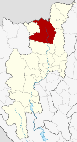
Chiang Dao district
|
Chiang Dao เชียงดาว |
|
|---|---|
| Province: | Chiang Mai |
| Surface: | 1882.1 km² |
| Residents: | 82,534 (2013) |
| Population density : | 46.1 U / km² |
| ZIP : | 50170 |
| Geocode : | 5004 |
| map | |

|
|
Amphoe Chiang Dao (in Thai : อำเภอ เชียงดาว ) is a district ( Amphoe - administrative district) in the northern part of Chiang Mai Province in the northern region of Thailand .
geography
Neighboring districts (clockwise from northeast): Amphoe Fang , Chai Prakan , Phrao , Mae Taeng in Chiang Mai Province, Amphoe Pai in Province Mae Hong Son and Amphoe Wiang Haeng again in Chiang Mai. In the north lies the Shan State of Myanmar .
The Pha Daeng National Park is located in the Chiang Dao district.
This is also the source of the Mae Nam Ping (Ping River) , the largest river in Chiang Mai Province.
history
Chiang Dao was a smaller city-state ( Müang ) in the northern Lanna Kingdom of Thailand . In the Thesaphiban administrative reform at the end of the 19th century, it became a “branch circle” ( King Amphoe ) of Chiang Mai Province. In 1908 it was upgraded to an Amphoe .
administration
Provincial Administration
Chiang Dao County is divided into seven tambon ("subdistricts" or "parishes"), which are further subdivided into 83 muban ("villages").
| No. | Surname | Thai | Muban | Pop. |
|---|---|---|---|---|
| 1. | Chiang Dao | เชียงดาว | 16 | 14,703 |
| 2. | Mueang Na | เมือง นะ | 14th | 28,631 |
| 3. | Mueang Ngai | เมือง งาย | 11 | 6,197 |
| 4th | Mae Na | แม่ นะ | 13 | 9,318 |
| 5. | Mueang Khong | เมือง ค อง | 6th | 3,898 |
| 6th | Ping khong | ปิ ง โค้ง | 16 | 11,561 |
| 7th | Thung Khao Phuang | ทุ่ง ข้าว พวง | 7th | 8,226 |
Local administration
There are seven municipalities with "small town" status ( Thesaban Tambon ) in the district:
- Mae Na (Thai: เทศบาล ตำบล แม่ นะ ) consisting of the complete Tambon Mae Na.
- Chiang Dao (Thai: เทศบาล ตำบล เชียงดาว ) consisting of parts of the Tambon Chiang Dao.
- Mueang Ngai (Thai: เทศบาล ตำบล เมือง งาย ) consisting of parts of the Tambon Mueang Ngai.
- Phra That Pu Kam (Thai: เทศบาล ตำบล พระ ธาตุ ปู่ ก่ำ ) consisting of parts of the Tambon Mueang Ngai.
- Ping Khong (Thai: เทศบาล ตำบล ปิ ง โค้ง ) consisting of the complete Tambon Ping Khong.
- Thung Khao Phuang (Thai: เทศบาล ตำบล ทุ่ง ข้าว พวง ) consisting of the complete tambon Thung Khao Phuang.
- Mueang Na (Thai: เทศบาล ตำบล เมือง นะ ) consisting of the complete tambon Mueang Na.
There are also two " tambon administration organizations " ( องค์การ บริหาร ส่วน ตำบล - Tambon Administrative Organizations, TAO)
- Chiang Dao (Thai: องค์การ บริหาร ส่วน ตำบล เชียงดาว ) consisting of parts of the Tambon Chiang Dao.
- Mueang Khong (Thai: องค์การ บริหาร ส่วน ตำบล เมือง ค อง ) consisting of the complete tambon Mueang Khong.
Individual evidence
- ↑ แจ้ง ความ กระทรวง มหาดไทย . In: Royal Gazette . 25, No. 15, July 12, 1908, pp. 447-448.
- ↑ 2013 population statistics ( Thai ) Department of Provincial Administration. Retrieved October 25, 2014.
Web links
- Information on Amphoe Chiang Dao from amphoe.com (in Thai)
- Information on Pha Daeng National Park at dnp.go.th (in English)
Coordinates: 19 ° 22 ′ N , 98 ° 58 ′ E