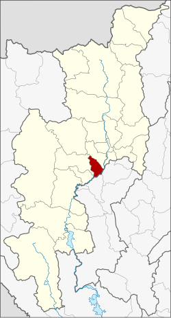
San Pa Tong district
|
San Pa Tong สันป่าตอง |
|
|---|---|
| Province: | Chiang Mai |
| Surface: | 178.18 km² |
| Residents: | 75,490 (2013) |
| Population density : | 431.2 U / km² |
| ZIP : | 50120 |
| Geocode : | 5012 |
| map | |

|
|

San Pa Tong District ( Thai : อำเภอ สันป่าตอง ) is a district ( Amphoe - administrative district) of Chiang Mai Province . Chiang Mai Province is located in the northern region of Thailand .
geography
Neighboring districts are (from the southwest clockwise): Amphoe Doi Lo , Mae Wang and Hang Dong Chiang Mai province, and Mueang Lamphun and Pa Sang of Lamphun province .
history
When the county was founded, it was still called Ban Mae . It was renamed San Pa Tong in 1939 .
In the southern part of the district, in Tambon Ban Klang, the remains of a walled city - Wiang Tha Kan - have been found, which was founded about 1000 years ago during the time of the Haripunchai kingdom .
administration
Provincial Administration
The district of San Pa Tong is divided into eleven tambon ("sub-districts" or "municipalities"), which are further subdivided into 120 muban ("villages").
| No. | Surname | Thai | Muban | Pop. |
|---|---|---|---|---|
| 1. | Yu Wa | ยุ หว่า | 15th | 13,367 |
| 2. | San sound | สัน กลาง | 9 | 5,047 |
| 3. | Tha Wang Phrao | ท่า วัง พร้าว | 7th | 3,426 |
| 4th | Makham Luang | มะขาม หลวง | 9 | 6,438 |
| 5. | Mae Ka | แม่ ก๊า | 14th | 7,270 |
| 6th | Ban Mae | บ้าน แม | 13 | 6,564 |
| 7th | Ban sound | บ้าน กลาง | 11 | 9,724 |
| 8th. | Thung Satok | ทุ่ง สะโตก | 12 | 6.312 |
| 10. | Thung Tom | ทุ่ง ต้อ ม | 11 | 7.170 |
| 14th | Nam Bo Luang | น้ำ บ่อ หลวง | 11 | 4,926 |
| 15th | Makhun Wan | มะ ขุน หวาน | 8th | 5,246 |
Note: The missing numbers (geocodes) refer to the tambon that make up Mae Wang County today.
Local administration
There are six municipalities with "small town" status ( Thesaban Tambon ) in the district:
- Yu Wa (Thai: เทศบาล ตำบล ยุ หว่า ) consisting of parts of the tambon Yu Wa.
- Ban Mae (Thai: เทศบาล ตำบล บ้าน แม ) consisting of the complete tambon Ban Mae.
- Thung Satok (Thai: เทศบาล ตำบล ทุ่ง สะโตก ) consisting of the complete tambon Thung Satok.
- Thung Tom (Thai: เทศบาล ตำบล ทุ่ง ต้อ ม ) consisting of parts of the tambon Thung Tom.
- Ban Klang (Thai: เทศบาล ตำบล บ้าน กลาง ) consisting of the parts of the Tambon Tha Wang Phrao, Makham Luang, Ban Klang, Makhun Wan.
- San Pa Tong (Thai: เทศบาล ตำบล สันป่าตอง ) consisting of the parts of the Tambon Yu Wa, Makham Luang, Thung Tom.
In addition, there are seven " Tambon Administration Organizations " ( องค์การ บริหาร ส่วน ตำบล - Tambon Administrative Organizations, TAO)
- San Klang (Thai: องค์การ บริหาร ส่วน ตำบล สัน กลาง ) consisting of the complete Tambon San Klang.
- Tha Wang Phrao (Thai: องค์การ บริหาร ส่วน ตำบล ท่า วัง พร้าว ) consisting of parts of the Tambon Tha Wang Phrao.
- Makham Luang (Thai: องค์การ บริหาร ส่วน ตำบล มะขาม หลวง ) consisting of parts of the Tambon Makham Luang.
- Mae Ka (Thai: องค์การ บริหาร ส่วน ตำบล แม่ ก๊า ) consisting of the complete Tambon Mae Ka.
- Ban Klang (Thai: องค์การ บริหาร ส่วน ตำบล บ้าน กลาง ) consisting of parts of the Tambon Ban Klang.
- Nam Bo Luang (Thai: องค์การ บริหาร ส่วน ตำบล น้ำ บ่อ หลวง ) consisting of the complete tambon Nam Bo Luang.
- Makhun Wan (Thai: องค์การ บริหารส่วน ตำบล มะ ขุน หวาน ) consisting of parts of the Tambon Makhun Wan.
Individual evidence
- ↑ พระราชกฤษฎีกา เปลี่ยน นาม อำเภอ กิ่ง อำเภอ และ ตำบล บาง แห่ง พุทธศักราช ๒๔๘๒ Royal Gazette Volume 56, Ed. 0 ก of April 17, 1939, pp. 354–364 (in Thai)
- ↑ http://www.bangkokpost.com/travel/5488_info_wiang-tha-kan.html
- ↑ 2013 population statistics ( Thai ) Department of Provincial Administration. Retrieved October 25, 2014.
Web links
Coordinates: 18 ° 38 ' N , 98 ° 54' E