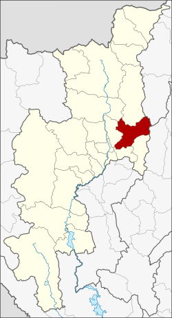
Doi Saket district
|
Doi Saket ดอยสะเก็ด |
|
|---|---|
| Province: | Chiang Mai |
| Surface: | 671.3 km² |
| Residents: | 63,397 (2013) |
| Population density : | 95.5 U / km² |
| ZIP : | 50220 |
| Geocode : | 5005 |
| map | |

|
|

Amphoe Doi Saket (in Thai : อำเภอ ดอยสะเก็ด ) is a district ( Amphoe - administrative district) in the east of Chiang Mai Province . Chiang Mai Province is located in the northern region of Thailand .
geography
Neighboring districts are (from the south clockwise) Amphoe Mae On , San Kamphaeng , San Sai , Mae Taeng and Phrao Chiang Mai province, and Wiang Pa Pao of Chiang Rai Province and Mueang Pan of Lampang province .
Mae Takhrai National Park, which protects the source of the Mae Nam Ping (Ping River) , is located in Doi Saket County .
education
The main campus of the Technical University of Rajamangala Lanna is located in Amphoe Doi Saket .
administration
Provincial Administration
Doi Saket County is divided into 14 tambon (“subdistricts” or “municipalities”), which are further subdivided into 112 muban (“villages”).
| No. | Surname | Thai | Muban | Pop. |
|---|---|---|---|---|
| 1. | Choeng Doi | เชิง ดอย | 13 | 11,430 |
| 2. | San Pu Loei | สัน ปู เลย | 15th | 12,950 |
| 3. | Luang Nuea | ลวง เหนือ | 10 | 6.139 |
| 4th | Pa pong | ป่า ป้อง | 8th | 4,007 |
| 5. | Sa-nga Ban | สง่า บ้าน | 5 | 2,093 |
| 6th | Pa Lan | ป่า ลาน | 6th | 2,021 |
| 7th | Talat Khwan | ตลาด ขวัญ | 6th | 3,896 |
| 8th. | Samran Council | สำราญราษฎร์ | 8th | 3,389 |
| 9. | Mae Khue | แม่ คือ | 6th | 5,472 |
| 10. | Talat Yai | ตลาด ใหญ่ | 5 | 3,639 |
| 11. | Mae Hoi Ngoen | แม่ ฮ้อ ย เงิน | 6th | 3,721 |
| 12. | Mae Pong | แม่ โป่ง | 10 | 5,532 |
| 13. | Pa Miang | ป่า เมี่ยง | 6th | 3,494 |
| 14th | Thep Sadet | เทพ เสด็จ | 8th | 1,614 |
Local administration
There are 13 municipalities with "small town" status ( Thesaban Tambon ) in the district:
- Pa Pong (Thai: เทศบาล ตำบล ป่า ป้อง ) consisting of parts of the Tambon Pa Pong.
- Sa-nga Ban (Thai: เทศบาล ตำบล สง่า บ้าน ) consisting of the complete tambon Sa-nga Ban, Pa Lan.
- Talat Khwan (Thai: เทศบาล ตำบล ตลาด ขวัญ ) consisting of the complete tambon Talat Khwan.
- Samran Rat (Thai: เทศบาล ตำบล สำราญราษฎร์ ) consisting of the complete Tambon Samran Rat.
- Mae Khue (Thai: เทศบาล ตำบล แม่ คือ ) consisting of the complete tambon Mae Khue.
- Talat Yai (Thai: เทศบาล ตำบล ตลาด ใหญ่ ) consisting of the complete Tambon Talat Yai.
- Mae Hoi Ngoen (Thai: เทศบาล ตำบล แม่ ฮ้อ ย เงิน ) consisting of the complete tambon Mae Hoi Ngoen.
- Pa Miang (Thai: เทศบาล ตำบล ป่า เมี่ยง ) consisting of the complete tambon Pa Miang.
- Doi Saket (Thai: เทศบาล ตำบล ดอยสะเก็ด ) consisting of the parts of the Tambon Choeng Doi, Luang Nuea, Pa Pong.
- Choeng Doi (Thai: เทศบาล ตำบล เชิง ดอย ) consisting of parts of the Tambon Choeng Doi.
- Mae Pong (Thai: เทศบาล ตำบล แม่ โป่ง ) consisting of the complete Tambon Mae Pong.
- Luang Nuea (Thai: เทศบาล ตำบล ลวง เหนือ ) consisting of parts of the tambon Luang Nuea.
- San Pu Loei (Thai: เทศบาล ตำบล สัน ปู เลย ) consisting of the complete Tambon San Pu Loei.
There is also a " tambon administration organizations " ( องค์การ บริหาร ส่วน ตำบล - Tambon Administrative Organizations, TAO)
- Thep Sadet (Thai: องค์การ บริหาร ส่วน ตำบล เทพ เสด็จ ) consisting of the complete tambon Thep Sadet.
Individual evidence
- ↑ Information on Mae Takhrai National Park from dnp.go.th ( Memento of the original from November 9, 2013 in the Internet Archive ) Info: The archive link has been inserted automatically and has not yet been checked. Please check the original and archive link according to the instructions and then remove this notice. (in English)
- ↑ 2013 population statistics ( Thai ) Department of Provincial Administration. Retrieved October 25, 2014.
Web links
Coordinates: 18 ° 52 ' N , 99 ° 8' E
