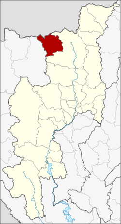
Amphoe Wiang Haeng
|
Wiang Haeng เวียง แหง |
|
|---|---|
| Province: | Chiang Mai |
| Surface: | 672.2 km² |
| Residents: | 27,283 (2013) |
| Population density : | 43.0 U / km² |
| ZIP : | 50350 |
| Geocode : | 5020 |
| map | |

|
|

Amphoe Wiang Haeng (in Thai : อำเภอ เวียง แหง ) is a district ( Amphoe - administrative district) in the north of Chiang Mai Province . Chiang Mai Province is located in the northern region of Thailand .
geography
Neighboring districts are (from the northeast clockwise): Amphoe Chiang Dao Chiang Mai province and Pai of Mae Hong Son province , and the Shan State in Myanmar .
history
Wiang Haeng was founded on May 5, 1981 as a "branch circle" ( King Amphoe ) . On November 4, 1993, Wiang Haeng was given full amphoe status.
administration
Provincial Administration
The district of Wiang Haeng is divided into three tambon ("subdistricts" or "communities"), which are further subdivided into 23 muban ("villages").
| No. | Surname | Thai | Muban | Pop. |
|---|---|---|---|---|
| 1. | Mueang Haeng | เมือง แหง | 12 | 8,787 |
| 2. | Piang Luang | เปีย ง หลวง | 6th | 14,924 |
| 3. | Saen Hai | แสน ไห | 5 | 3,572 |
Local administration
There is one municipality with "small town" status ( Thesaban Tambon ) in the district:
- Saen Hai (Thai: เทศบาล ตำบล แสน ไห ) consisting of the complete Saen Hai tambon.
There are also two " tambon administration organizations " ( องค์การ บริหาร ส่วน ตำบล - Tambon Administrative Organizations, TAO)
- Mueang Haeng (Thai: องค์การ บริหาร ส่วน ตำบล เมือง แหง ) consisting of the complete tambon Mueang Haeng.
- Piang Luang (Thai: องค์การ บริหาร ส่วน ตำบล เปีย ง หลวง ) consisting of the complete tambon Piang Luang.
Individual evidence
- ↑ ประกาศ กระทรวง มหาดไทย เรื่อง แบ่ง ท้องที่ อำเภอ เชียงดาว จังหวัด เชียงใหม่ ตั้ง เป็น กิ่ง อำเภอ เวียง แหง Royal Gazette Volume 98, Ed. 68 ง of May 5, 1981, p. 1282 (in Thai)
- ↑ พระราชกฤษฎีกา ตั้ง อำเภอ ลำ ทับ อำเภอ ร่องคำ อำเภอ เวียง แหง อำเภอ นา โยง อำเภอ แก้ง สนาม นาง อำเภอ โนน แดง อำเภอ บ้านหลวง อำเภอ กะพ้อ อำเภอ ศรี บรรพต บรรพต อำเภอ แก่ง กระจาน อำเภอ อำเภอ หนอง สูง อำเภอ สบ เมย อำเภอ เมย วดี อำเภอ โคก เจริญ อำเภอ ทุ่งหัวช้าง อำเภอ วัง ขาว ขาว ขาว ขาว ขาว ขาว หิน อำเภอ ดอนพุด อำเภอ บึง โขง หลง และ อำเภอ ห้วย ค ต พ.ศ. ๒๕๓๖ Royal Gazette Volume 110, ed. 179 ก ฉบับ พิเศษ (special) of November 3, 1993, pp. 1–3 (in Thai)
- ↑ 2013 population statistics ( Thai ) Department of Provincial Administration. Retrieved October 25, 2014.
Web links
Coordinates: 19 ° 34 ' N , 98 ° 38' E