Amphoe Omkoi
|
Omkoi อมก๋อย |
|
|---|---|
| Province: | Chiang Mai |
| Surface: | 2,093.8 km² |
| Residents: | 60,429 (2013) |
| Population density : | 26.1 U / km² |
| ZIP : | 50310 |
| Geocode : | 5018 |
| map | |

|
|

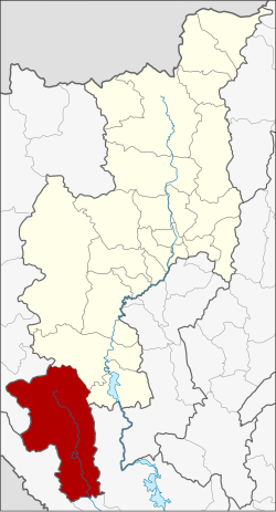
Amphoe Omkoi (in Thai : อำเภอ อมก๋อย ) is a district ( Amphoe - administrative district) in the extreme southwest of Chiang Mai Province . Chiang Mai Province is located in the northern region of Thailand .
geography
Neighboring districts are (from the south clockwise) Amphoe Hot and Doi Tao Chiang Mai province, Sam Ngao , Mae Ramat and Tha Song Yang of Tak Province and Sop Moei the Mae Hong Son province .
history
Omkoi was founded on April 19, 1929 as "Branch Circle " ( King Amphoe ) and was subordinate to the Hot District. At that time it consisted of the three tambon Omkoi, Yang Piang and Mae Tuen. On July 23, 1958, Omkoi received full amphoe status.
administration
Provincial Administration
Omkoi County is divided into six tambon ("subdistricts" or "municipalities"), which are further subdivided into 95 muban ("villages").
| No. | Surname | Thai | Muban | Pop. |
|---|---|---|---|---|
| 1. | Omkoi | อมก๋อย | 20th | 17,579 |
| 2. | Yang Piang | ยาง เปีย ง | 17th | 9,023 |
| 3. | Mae Tuen | แม่ ตื่น | 16 | 9,962 |
| 4th | Mon Chong | ม่อน จอง | 9 | 5,723 |
| 5. | Sop Khong | สบ โขง | 12 | 7,700 |
| 6th | Well Kian | นา เกียน | 21st | 10,442 |
Local administration
There is one municipality with "small town" status ( Thesaban Tambon ) in the district:
- Omkoi (Thai: เทศบาล ตำบล อมก๋อย ) consisting of parts of the Tambon Omkoi.
In addition, there are six " tambon administration organizations " ( องค์การ บริหาร ส่วน ตำบล - Tambon Administrative Organizations, TAO)
- Omkoi (Thai: องค์การ บริหาร ส่วน ตำบล อมก๋อย ) consisting of parts of the Tambon Omkoi.
- Yang Piang (Thai: องค์การ บริหาร ส่วน ตำบล ยาง เปีย ง ) consisting of the complete tambon Yang Piang.
- Mae Tuen (Thai: องค์การ บริหาร ส่วน ตำบล แม่ ตื่น ) consisting of the complete tambon Mae Tuen.
- Mon Chong (Thai: องค์การ บริหาร ส่วน ตำบล ม่อน จอง ) consisting of the complete tambon Mon Chong.
- Sop Khong (Thai: องค์การ บริหาร ส่วน ตำบล สบ โขง ) consisting of the complete tambon Sop Khong.
- Na Kian (Thai: องค์การ บริหาร ส่วน ตำบล นา เกียน ) consisting of the complete tambon Na Kian.
Individual evidence
- ↑ แจ้ง ความ กระทรวง มหาดไทย เรื่อง ตั้ง กิ่ง อำเภอ . In: Royal Gazette . 46, No. 0 ง , April 28 1929, pp. 296-297.
- ↑ พระราชกฤษฎีกา จัดตั้ง อำเภอ กระสัง อำเภอ กระนวน อำเภอ บางกอกใหญ่ อำเภอ ขุน หาร อำเภอ พนา อำเภอ ปากช่อง อำเภอ วังเหนือ อำเภอ วัง ชิ้น อำเภอ แม่ทา อำเภอ หนอง หมู อำเภอ สระแก้ว สระแก้ว อำเภอ อมก๋อย อำเภอ บางซ้าย บางซ้าย อำเภอ ทับสะแก อำเภอ บุณฑริก อำเภอ ลานสะกา อำเภอ จอมบึง อำเภอ ท่ายาง อำเภอ สามเงา อำเภอ อำเภอ ชานุมาน บ้านเขว้า บ้านเขว้า บ้านเขว้า บ้านเขว้า บ้านเขว้า บ้านเขว้า อำเภอ แม่พริก อำเภอ ท่าสองยาง อำเภอ สะเมิง อำเภอ หนองแขม อำเภอ พระแสง พ.ศ. ๒๕๐๑ . In: Royal Gazette . 75, No. 55 ก , July 22 1958, pp. 321-327.
- ↑ 2013 population statistics ( Thai ) Department of Provincial Administration. Retrieved October 25, 2014.
Web links
Coordinates: 17 ° 48 ' N , 98 ° 22' E
