Tak (province)
| Tak | |
|---|---|
| ตาก | |

|
|
| statistics | |
| Capital: | Tak |
| Telephone code: | 055 |
| Surface: |
16,406.6 km² 4. |
| Residents: |
519,662 (2009) 49. |
| Population density : | 32 E / km² 75. |
| ISO 3166-2 : | |
| Governor : | Suriya Prasatbanthite |
| map | |

Tak ( Thai ตาก [ tàːk ]) is a province ( Changwat ) in the west of the northern region of Thailand . It is one of the largest and at the same time one of the most sparsely populated provinces in the country. The capital of the province is also called Tak .
geography
The province borders Myanmar to the west , with which Tak has the longest border of Thailand's provinces. The topography is mountainous and rugged. There are many waterfalls, rivers and caves.
| Neighboring provinces and areas: | |
|---|---|
| north | Mae Hong Son , Chiang Mai , Lamphun and Lampang |
| east | Sukhothai , Kamphaeng Phet , Nakhon Sawan and Uthai Thani |
| south | Kanchanaburi |
| west | Land border with Myanmar ( Kayin State ) |
Important cities
climate
The climate is tropical - monsoonal with moderate influences. The maximum temperature in 2009 was 40.2 ° C, the lowest temperature was measured at 9.7 ° C. On 109 rainy days fell in the same year 1006.4 mm of precipitation.
|
Average monthly temperatures and precipitation for Tak
|
||||||||||||||||||||||||||||||||||||||||||||||||||||||||||||||||||||||||||||||||||||||||||||||||||||||||||||||||||||||||||||||||||||||||||||||||||||||||||||||||||||||||||||||||||||
population
According to the 2000 census data, 93% of the province's population were Thai nationals, up from 99.5% in 1990. 95.1% were Buddhists, 1.2% Muslim. 24.3% said they spoke one of the languages of the so-called hill tribe, mainly from the Karen group ; in 1990 it was 18.1%. Another 2.6% spoke Burmese or Mon language .
According to the UN refugee agency UNHCR , around 100,000 refugees from neighboring Myanmar were living in camps in the border area of the Tak Province in 2006. The largest of these is the Mae La refugee camp in Tha Song Yang district , where over 45,000 people, mainly members of the Karen ethnic group, lived.
Economy and Importance
In 2008, the "Gross Provincial Product" (was GDP ) of the province 36.611 billion baht . The minimum wage in the province is 162 baht per day (around € 4). More than 60% of the workforce is employed in agriculture.
Data
The table below shows the share of the economic sectors in the gross provincial product in percent:
| Industry | 2006 | 2007 | 2008 |
|---|---|---|---|
| Agriculture | 28.0 | 27.1 | 30.6 |
| Industry | 14.2 | 16.1 | 18.9 |
| Other | 57.8 | 56.8 | 50.5 |
The industry that made the greatest contribution to the province's economic output in 2011 was agriculture with 8.538 billion baht, followed by manufacturing with 6.403 billion baht and wholesale and retail with 4.404 billion baht.
Land use
The following land use is documented for the province:
- Forest area: 7,942,381 Rai (4,964.0 km²), 77.5% of the total area
- Agricultural area: 1,382,579 rai (867.2 km²), 13.5% of the total area
- Unclassified area: 924,196 rai (577.6 km²), 9.0% of the total area
The province can play an important role as soon as the Asian Highway from Istanbul to Ubon Ratchathani becomes continuously passable. This is currently largely failing in Myanmar , which has no interest in opening up the country.
Dams
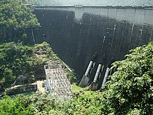
The dam of the Bhumibol Dam , built between 1958 and 1964, damms the Mae Nam Ping (Ping River) into an approx. 300 km² reservoir. The associated hydropower plant is the most powerful in Thailand.
history
The landscape of the Tak Province was settled at least 2000 years ago and it is assumed that a small empire had formed here long before the Sukhothai Kingdom was formed and Tak could be brought under control. The city of Ban Tak was established around 663 under Queen Chamadevi , who was a princess of the Lop Buri Kingdom . Tak later formed the western outpost for Sukhothai. During the reign of King Maha Thammaracha (ruled 1568-1590) Tak was lost to the Burmese, but was recaptured in 1584 by his son Naresuan the Great (ruled 1590-1605) when he was still prince and viceroy of the northern provinces. During the early Bangkok ( Rattanakosin ) period, the city of Tak was relocated to the east bank of the Ping River.
The future King Taksin , who united the empire after the fall of the Kingdom of Ayutthaya , was governor here for many years. The name Tak-Sin is derived from this position.
Symbols
The seal of the province shows King Naresuan on the royal elephant. Sometimes a Garuda , the state symbol of Thailand, is shown under the elephant . Naresuan is shown pouring holy water over the earth, a symbolic act that symbolizes the country's independence. This gesture refers to the war against Burma in 1584 after Tak was the first border town to be liberated from Burmese control.
The local tree is the Asian Jatoba ( Xylia kerrii , in Thai : Daeng ), the local flower is that of the orchid tree ( Bauhinia sp. ).
The motto of Tak Province is:
Tak is full of appealing and beautiful landscapes,
The great Bhumibol Dam was built here,
The land of the brave King Taksin ,
Big trees and pretty forests are evergreen.
Attractions
- Thi Lo Su (Thai: ที ล อ ซู ), Thailand's largest waterfall is located (about 200 meters high and 400 meters wide) in Wildlife Reserve Umphang ( "Umphang Wildlife Sanctuary") in Umphang.
- Lan Sang National Park
- Taksin Maharat National Park
- Mae Moei National Park
- Namtok Pha Charoen National Park
- Mae Ping National Park
- Mae Wa National Park
Administrative units
Provincial Administration
The province is divided into 9 districts ( Amphoe ) . These are further divided into 63 parishes ( tambon ) and 493 villages ( muban ) .
|
Local administration
A provincial administrative organization ( บริหาร ส่วน จังหวัด , อบ จ for short , Ongkan Borihan suan Changwat ; English Provincial Administrative Organization , PAO) exists for the entire area of the province .
In the province there is a commune with “big city” status ( Thesaban Nakhon ) : Mae Sot and a commune with “city” status ( Thesaban Mueang ) : the provincial capital Tak . There are also 12 municipalities with “small town” status ( Thesaban Tambon ) .
literature
- Thailand in Figures 2011 . 13th edition. Alpha Research, Nonthaburi 2011, ISBN 978-616752603-4 .
Web links
- Province website (in Thai)
- Sights of the province of Tak , website of the "Tourism Authority of Thailand" ( TAT ) (in German and English) accessed on October 21, 2013
Individual evidence
- ↑ Governor of Tak
- ↑ Key indicators of the population and households, Population and Housing Census 1990 and 2000: Tak (PDF)
- ↑ Myanmar Thailand border. Refugee population by gender. As at end April 2006 . (PDF) UNHCR, May 30, 2006.
- ↑ a b c Thailand in Figures . 2011, p. 359.
- ^ Gross Provincial Product at Current Market Prices: Northern Provinces, National Economic and Social Development Board, 2011.
- ↑ Department of Provincial Administration : As of 2012 (in Thai)
Coordinates: 16 ° 53 ' N , 99 ° 7' E


