Songkhla Province
| Songkhla | |
|---|---|
| สงขลา | |

|
|
| statistics | |
| Capital: | Songkhla |
| Telephone code: | 074 |
| Surface: |
7,939.9 km² 26. |
| Residents: |
1,343,954 (2009) 11. |
| Population density : | 182 E / km² 13. |
| ISO 3166-2 : | |
| Governor : | Krisda Boonrach |
| map | |
Songkhla ( Thai : สงขลา ) is a province ( Changwat ) in the southern region of Thailand . The capital of Songkhla Province is also called Songkhla .
General
The name Songkhla goes back to the old name Singhala (City of Lions), near the provincial capital there is a mountain in the shape of a lion . In contrast to most of the other provinces in Thailand, the provincial capital is not the largest city in the province, but in this case Hat Yai .
The province has been governor since Krisda Boonrach.
location
Songkhla is located on the Malacca Peninsula on the coast of the Gulf of Thailand . The highest point is the Khao Mai Kaeo with 821 meters above sea level. The coastline is characterized by sandy banks.
In the north, the province has a share in the Thale Sap , the largest natural lake in the country. This shallow lake has a north-south extension of about 78 kilometers and covers an area of 1040 km² . The banks merge into a flat landscape. At the mouth of the lake in the Gulf of Thailand, the fresh water turns into brackish water, the mouth is a habitat for extraordinary and rare animals. The Thale Sap Songkhla , also called Songkhla Lake, is very similar to it and lies south of the former, as well as north and west of the provincial capital Songkhla , is connected to it as part of a lagoon system and belongs entirely to the territory.
In the south rise mountain ranges that form a natural border with Malaysia .
| Adjacent provinces and areas: | |
|---|---|
| north | Phatthalung and Nakhon Si Thammarat |
| east | Gulf of Siam and Pattani |
| south | Yala and the border with Malaysia |
| west | Satun |
Important cities
climate
The climate is tropical - monsoonal and, as in all southern provinces of the country, very humid. The maximum temperature in 2008 was 36.7 ° C, the lowest temperature was measured at 23.2 ° C. On 153 rainy days in the same year fell 2119.3 mm of precipitation.
climate
| Songkhla | ||||||||||||||||||||||||||||||||||||||||||||||||
|---|---|---|---|---|---|---|---|---|---|---|---|---|---|---|---|---|---|---|---|---|---|---|---|---|---|---|---|---|---|---|---|---|---|---|---|---|---|---|---|---|---|---|---|---|---|---|---|---|
| Climate diagram | ||||||||||||||||||||||||||||||||||||||||||||||||
| ||||||||||||||||||||||||||||||||||||||||||||||||
|
Average monthly temperatures and rainfall for Songkhla
|
|||||||||||||||||||||||||||||||||||||||||||||||||||||||||||||||||||||||||||||||||||||||||||||||||||||||||||||||||||||||||||||||||||||||||||||||||||||||||||||||||||||
population
According to the 2000 census data, 99.8% of the population were Thai citizens. 76.6% were Buddhists, 23.2% Muslim. The latter were mainly concentrated in the five southern and eastern Amphoe Chana , Thepha , Na Thawi , Saba Yoi and Sadao , where they made up the majority of the population. 4.6% of residents stated that they speak Malay (or a Malay dialect, the Yawi ). The Thai-speaking Muslims are called Sam-Sam .
The proportion of Thai people of Chinese descent can not be read from the census data because they are highly integrated and now predominantly speak Thai. Yet their legacy is very present in this province. This is evident, for example, through the high-profile celebrations of Chinese festivals, such as the Chinese New Year , the Moon Festival in Songkhla and the Festival of the Nine Emperor Gods in Hat Yai, as well as the erection of statues of the Bodhisattva Guanyin, who come from the Chinese Mahayana Buddhism, or the Hokkien - Chinese folk religion originating spirit mediums rituals (tang-ki) .
Economy and Importance
Along with Phatthalung and Nakhon Si Thammarat, Songkhla is the largest rice producer in southern Thailand. The main city of Hat Yai is at the center of the province's economic development.
Songkhla Lake is rich in fish. A large part of the population lives from fishing . The southernmost (now discarded) variant of the Kra Canal was planned through the province and Lake Songkhla .
In 2008, the "Gross Provincial Product" (was GDP ) of the province of 166,174 million baht. The minimum wage in the province is 176 baht per day (around € 4).
Data
The table below shows the share of the economic sectors in the gross provincial product in percent.
| Industry | 2006 | 2007 | 2008 |
|---|---|---|---|
| Agriculture | 19.5 | 19.6 | 20.2 |
| Industry | 28.8 | 28.4 | 27.7 |
| Other | 51.7 | 52.0 | 52.1 |
All figures in%
Land use
The following land use is documented for the province:
- Forest area : 688,862 Rai (430.5 km²), 14.9% of the total area
- Agricultural area : 2,277,479 Rai (1,423.4 km²), 49.3% of the total area
- Unclassified area : 1,654,840 rai (1,034.3 km²), 35.8% of the total area
traffic
Airport
railroad
- Hat Yai Railway Station
- Chana train station
- Tha Maenglak train station
- Ko Sa Bo train station
- Thepha station
- Tapaet station
Bus transport
- Songkhla bus terminal
- Hat Yai bus terminal
Streets
The province's most important road axes are Thanon Phetkasem (National Road 4), Asian Highway 2 , which connects Bangkok with Kuala Lumpur and Singapore, and National Roads 42 and 43. The 2.6 kilometer long Tinsulanonda Bridge is Thailand's longest concrete bridge. It connects the island of Ko Yo with the city of Songkhla and Amphoe Singhanakhon.
Educational institutions
Universities
- Prince of Songkhla University , parts in Hat Yai , Pattani , Phuket , Surat Thani and Trang
- Thaksin University
- Songkhla Rajabhat University
- Rajamangala University of Technology Srivijaya Southern Campus
Colleges
- Tinnasulanon Fishery College
- Songkhla Nursing College
- Songkhla Technology College
- Songkhla Polytechnic College
- Has Yai Technical College
- International Buddhist College
- Mahapanya Vidayalai , Mahayana International Buddhist College
history
Residents from the mountain caves came to Songkhla Lake and the Sathing Phra Peninsula at least 3000 years ago and settled there. Finds from the Bronze Age show early economic and commercial activity along the coast of the Gulf of Siam. Indian fishermen and merchants settled on the Sathing Phra peninsula as early as the 1st and 2nd centuries. An early port city formed through which Mahayana Buddhism was introduced in the 9th century . In the 12th century, after the fall of the Srivijaya Empire , the residents of Ceylon converted to Theravada Buddhism .
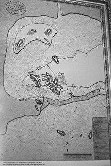
Around 1605, Dato Moghal (or Mogol), a Persian Muslim leader, had the city of Hua Khao Daeng expanded into a fortified port city for overseas trade. He proclaimed himself Sultan of Singora, but recognized the supremacy of the Kingdom of Ayutthaya . Through a liberal economic policy and duty-free, Singora developed into an important port for trade across the Malay Peninsula, in competition with Nakhon Si Thammarat and Pattani. Dato Moghal's son, Sultan Sulaiman, declared Singora independent from Ayutthaya in 1642. In 1680, the forces of the Siamese King Narai took the city and completely destroyed it.
In 1685, Siam's Foreign Minister Constantine Phaulkon offered to cede Singora to France. The French East India Company was supposed to establish a trading post and a military base here. At the end of the assignment, the Siamese envoy Kosa Pan traveled to Versailles in 1686/87 . However, the French naval minister Marquis de Seignelay refused: There was no usable port, the place was devastated and completely useless.
Songkhla initially became part of Phatthalung Province and later Nakhon Si Thammarat. The city grew again under the leadership of the Chinese traders. More houses were built on a narrow plain at the end of the Sathing Phra Peninsula. In 1777, King Taksin appointed the Chinese-born bird's nest tax farmer Chin Yiang Sae Hao, head of the economically most influential family, as governor of Songkhla Province. The previous governor who was killed in the process instigated a revolt in 1786, which was only pushed back four months later. The governorship remained in the Yiangs' family for eight generations - 126 years. She was later given the family name Na Songkhla .
As part of the centralization of the Siamese provincial administration, the eighth governor of the Na Songkhla family was retired in 1901. Songkhla then became part of the Monthon Nakhon Si Thammarat. A large rubber plantation was built. In 1933 the Monthon were abolished and all provinces were directly subordinated to the central government.
See also: History of Thailand and corresponding entry in Songkhla
Attractions
( See entry in Songkhla )
- Sathing Phra Peninsula - with many beautiful beaches and old facilities from the time of the Srivijaya Empire .
- Khao Nam Khang - (Amphoe Na Thawi), once a secret cave system for communist guerrillas , today a tourist attraction with shops and restaurants underground. The caves were hand-dug in just nine years and form the longest man-made cave system in Thailand.
- Boriphat Waterfall - (Amphoe Rattaphum), in the dense evergreen rainforest, the water falls over several cliffs into an idyllic bathing lake.
coat of arms
The coat of arms of the province shows the house of a sea snail on a vessel with a glass decoration. The snail shell suggests the long sea coast to the Gulf of Siam . It was probably originally worn as a decorative element by the Prince of Songkhla on the jacket .
The neem tree ( Azadirachta excelsa ) is a symbol of the province .
The motto of Songkhla Province is:
- "You can observe many water birds,
- Samila beach is nice and clean,
- The big city borders two lakes
- The richest business center in the south,
- The bridge is reminiscent of the statesman Pa ,
- Full of colored flowers called Fuang Fa. "
politics
Songkhla is the home province of Prem Tinsulanonda , a general and politician who was Prime Minister from 1980 to 1988 and has been President of the Privy Council since 1995 . It is very popular in Songkhla due to its origins. The Pathammaron Museum dedicated to him, the Tinsulanonda Bridge named after him (the longest concrete bridge in Thailand) and the Tinsulanon Stadium take this into account.
The local Democratic Party is also trying to profit from Prem's popularity , which Prem does not belong to (he was always non-party), but which belonged to his government and which presents itself as a representative of his politics. In every election since 1992, she has won all of the provincial constituencies. A prominent national politician from the Democrats, the former party vice and deputy prime minister Trairong Suwankiri, also comes from this province. In the 2007 constitutional referendum, Songkhla was one of the provinces with the highest approval ratings (91.0% versus 7.5% no).
Administrative units
Provincial Administration
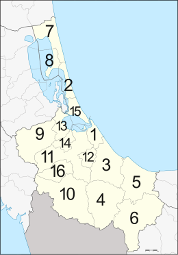
The province is divided into 16 districts ( Amphoe ). These are further subdivided into 127 parishes ( tambon ) and 987 villages ( muban ).
|
Local administration
A provincial administrative organization ( บริหาร ส่วน จังหวัด , อบ จ for short , Ongkan Borihan suan Changwat ; English Provincial Administrative Organization , PAO) exists for the entire area of the province .
There are two major cities in the province ( เทศบาล นคร - Thesaban Nakhon ):
and eight cities ( เทศบาล เมือง - Thesaban Mueang ):
- Khao Rup Chang ( เทศบาล เมือง เขา รูป ช้าง ),
- Khlong Hae ( เทศบาล เมือง คลอง แห ),
- Kuan Lang ( เทศบาล เมือง ควน ลัง ),
- Kho Hong ( เทศบาล เมือง คอ หงส์ ),
- Singha Nakhon ( เทศบาล เมือง สิงห นคร ),
- Padang Besar ( เทศบาล เมือง ปา ดัง เบ ซาร์ ),
- Ban Phru ( เทศบาล เมือง บ้าน พรุ ) and
- Sadao ( เทศบาล เมือง สะเดา ).
There are also 21 small towns ( เทศบาล ตำบล - Thesaban Tambon ).
Individual evidence
- ↑ Current governor of the province ( Memento of the original from February 21, 2012 in the Internet Archive ) Info: The archive link has been inserted automatically and has not yet been checked. Please check the original and archive link according to the instructions and then remove this notice.
- ↑ Kobkua Suwannathat-Pian: National Identity, the "Sam-Sams" of Satun, and the Thai Malay Muslims. In: Thai South and Malay North: Ethnic Interactions on the Plural Peninsula. National University of Singapore Press, 2008, pp. 158-159.
- ^ Marc Askew: Materializing merit. The symbolic economy of religious monuments and tourist pilgrimage in contemporary Thailand. In: Religious Commodifications in Asia. Marketing Gods. Routledge, Abingdon / New York 2008, pp. 115-116.
- ↑ Michael K. Jerryson: Buddhist Fury. Religion and Violence in Southern Thailand. Oxford University Press, Oxford / New York 2011, p. 47.
- ^ Jovan Maud: Fire and Water. Ritual Innovation, Tourism and Spontaneous Religiosity in Hat Yai, Southern Thailand. In: Faith in the Future. Understanding the Revitalization of Religions and Cultural Traditions in Asia. Brill, Leiden 2013, pp. 269-296.
- ↑ a b c Thailand in Figures (2011), p. 411.
- ↑ a b c History of the Province ( Memento of the original from March 9, 2012 in the Internet Archive ) Info: The archive link was inserted automatically and has not yet been checked. Please check the original and archive link according to the instructions and then remove this notice. (Thai)
- ↑ Srisuporn Choungsakul: The Role of Chinese Traders on the Growth of Songkhla. In: Manusya - Journal of Humanities , Volume 9, No. 2, 2006, pp. 44-65, at p. 45.
- ↑ Michel Jacq-Hergoualc'h: La France et le Siam de 1680 à 1685. Histoire d'un échec. In: Revue française d'histoire d'outre-mer , Volume 82, No. 308, 1995, pp. 257-275, on p. 272.
- ↑ Morgan sports, Kanika Chan Sang: Kosapan face aux intrigues françaises. In: Journal of the Siam Society , Volume 83, 1995, pp. 79-91, at p. 83.
- ↑ Information about Songkhla ( memento of the original from November 9, 2013 in the Internet Archive ) Info: The archive link was automatically inserted and not yet checked. Please check the original and archive link according to the instructions and then remove this notice. (PDF; 6.7 MB)
- ^ Marc Askew: Performing Political Identity. The Democrat Party in Southern Thailand. Silkworm Books, 2008, p. 35.
- ↑ Department of Provincial Administration : As of 2012 (in Thai)
literature
- Thailand in Figures 2011 . Nonthaburi: Alpha Research 13 A. 2011. ISBN 9786167526034 .
Web links
- Province website (in Thai)
- Information about Songkhla (in Thai; PDF; 6.7 MB)
Coordinates: 7 ° 12 ' N , 100 ° 36' E


