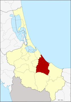
Amphoe Chana
|
Chana จะ นะ |
|
|---|---|
| Province: | Songkhla |
| Surface: | 502.98 km² |
| Residents: | 102.009 (2012) |
| Population density : | 187.7 U / km² |
| ZIP : | 90130 |
| Geocode : | 9003 |
| map | |

|
|
Amphoe Chana ( Thai : อำเภอ จะ นะ , Malai : Chenok ) is a district ( Amphoe - administrative district) in the southeast of Songkhla Province . The Songkhla Province is located in the southern region of Thailand on the coast to the Gulf of Thailand .
geography
Neighboring districts and areas (clockwise from east): Amphoe Thepha , Na Thawi , Sadao , Hat Yai , Na Mom and Mueang Songkhla . All of the Amphoe are in Songkhla Province. In the northeast lies the Gulf of Thailand .
history
Originally, today's Chana County was one of the four Mueang , which were subordinate to Mueang Phatthalung, together with Palian , Thepha and Songkhla . When Songkhla was separated from Phatthalung and assigned to Bangkok, Chana Songkhla was assigned.
In 1917 the district was renamed Ban Na after the central tambon . In 1924, the government changed the name to Chana to avoid confusion with the Ban Na San district in Surat Thani Province .
administration
Provincial Administration
Amphoe Singhanakhon is divided into 14 subdistricts ( tambon ) , which are further subdivided into 138 village communities ( muban ) .
| No. | Surname | Thai | Muban | Pop. |
|---|---|---|---|---|
| 1. | Ban Na | บ้านนา | 10 | 15,705 |
| 2. | Pa Ching | ป่า ชิง | 9 | 4,818 |
| 3. | Saphan Mai Kaen | สะพาน ไม้แก่น | 8th | 6,405 |
| 4th | Sakom | สะกอ ม | 9 | 8,191 |
| 5. | Well what | นาหว้า | 12 | 7,550 |
| 6th | Well Thap | นา ทับ | 14th | 12,628 |
| 7th | Nam Khao | น้ำขาว | 11 | 3.810 |
| 8th. | Khun Tat Wai | ขุน ตัด หวาย | 9 | 3,035 |
| 9. | Tha Mo Sai | ท่า หมอ ไทร | 11 | 6,552 |
| 10. | Chanong | จะ โหน ง | 11 | 7,604 |
| 11. | Khu | คู | 9 | 6,250 |
| 12. | Khae | แค | 7th | 4,244 |
| 13. | Khlong Pia | คลอง เปียะ | 10 | 5,482 |
| 14th | Taling Chan | ตลิ่งชัน | 8th | 9,735 |
Local administration
There are three small towns ( Thesaban Tambon ) in the county:
- Chana ( เทศบาล ตำบล จะ นะ ) consists of parts of the Tambon Ban Na.
- Ban Na ( เทศบาล ตำบล บ้านนา ) consists of further parts of the Tambon Ban Na.
- Na Thap ( เทศบาล ตำบล นา ทับ ) consists of the whole Tambon Na Thap.
There are also 12 “tambon administration organizations” (TAO, องค์การ บริหาร ส่วน ตำบล ) for the tambon in the county that do not belong to any city.
Individual evidence
- ↑ ประกาศ กระทรวง มหาดไทย เรื่อง เปลี่ยน ชื่อ อำเภอ . In: Royal Gazette . 34, No. 0 ก , April 29, 1917, pp. 40-68.
- ↑ ประกาศ เปลี่ยน นาม อำเภอ บ้านนา ใน มณฑล นครศรีธรรมราช Royal Gazette, Volume 41, Ed. ง June 1, 1924, p. 539 (in Thai)
- ↑ Population statistics 2012 . Department of Provincial Administration. Retrieved July 13, 2014.
Web links
Coordinates: 6 ° 55 ' N , 100 ° 44' E
