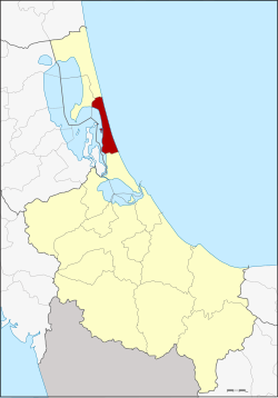
Amphoe Sathing Phra
|
Sathing Phra สทิงพระ |
|
|---|---|
| Province: | Songkhla |
| Surface: | 120.0 km² |
| Residents: | 48,543 (2012) |
| Population density : | 417.4 U / km² |
| ZIP : | 90190 |
| Geocode : | 9002 |
| map | |

|
|
Amphoe Sathing Phra ( Thai : อำเภอ สทิงพระ ) is a district ( Amphoe - administrative district) in the north of Songkhla Province . The Songkhla Province is located in the southern region of Thailand on the coast to the Gulf of Thailand .
geography
Neighboring districts and areas (clockwise from south): Amphoe Singhanakhon in Songkhla Province, Amphoe Pak Phayun in Phatthalung Province, and Amphoe Krasae Sin and Ranot again in Songkhla. To the east lies the Gulf of Thailand .
The western part of the district is the bank of the Thale Luang , the northern part that of the Songkhla Lake .
Attractions
- There are two beaches worth seeing in Sathing Phra County:
- Maharat Beach (Thai: หาด มหาราช ) - 2 km northeast of the district capital in the Tambon Chathing Phra, fine sand and quiet, with pine trees.
- Sathing Phra Beach (Thai: หาด สทิงพระ ) - in the Tambon Kradang-nga.
history
The original name of the county was Chathing Phra , but it was renamed Sathing Phra in 1961.
administration
Provincial Administration
Amphoe Sathing Phra is divided into eleven sub-districts ( tambon ) , which are further subdivided into 79 village communities ( muban ) .
| No. | Surname | Thai | Villages | Pop. |
|---|---|---|---|---|
| 1. | Chathing Phra | จะ ทิ้ง พระ | 7th | 6,258 |
| 2. | Kradang-nga | กระดังงา | 7th | 4,546 |
| 3. | Sanam Chai | สนาม ชัย | 5 | 3,909 |
| 4th | Di Luang | ดี หลวง | 8th | 3,430 |
| 5. | Chumphon | ชุมพล | 7th | 5,338 |
| 6th | Khlong Ri | คลอง รี | 9 | 3,610 |
| 7th | Khu Khut | คู ขุด | 9 | 5,181 |
| 8th. | Tha Hin | ท่า หิน | 9 | 4.102 |
| 9. | Wat Chan | วัด จันทร์ | 6th | 3.714 |
| 10. | Bo Daeng | บ่อ แดง | 6th | 4,794 |
| 11. | Bo Dan | บ่อ ดาน | 6th | 3,661 |
Local administration
Sathing Phra ( เทศบาล ตำบล สทิงพระ ) is a small town ( Thesaban Tambon ) in the district, it consists of parts of the Tambon Chathing Phra.
There are also eleven “tambon administration organizations” (TAO, องค์การ บริหาร ส่วน ตำบล ) for the tambon or the parts of tambon in the county that do not belong to any city.
Individual evidence
- ↑ พระราชกฤษฎีกา เปลี่ยน ชื่อ อำเภอ และ ตำบล บาง แห่ง พ.ศ. ๒๕๐๔ Royal Gazette, Volume 78, Issue 33 ก April 11, 1961, p. 382 (in Thai)
- ↑ Population statistics 2012 ( Thai ) Department of Provincial Administration. Retrieved November 10, 2014.
Web links
Coordinates: 7 ° 28 ' N , 100 ° 26' E
