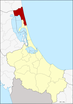
Amphoe Ranot
|
Ranot ระโนด |
|
|---|---|
| Province: | Songkhla |
| Surface: | 783.8 km² |
| Residents: | 66,951 (2012) |
| Population density : | 90.5 U / km² |
| ZIP : | 90140 |
| Geocode : | 9007 |
| map | |

|
|
Amphoe Ranot ( Thai : อำเภอ ระโนด , Malai : Renut ) is the northernmost district ( Amphoe - administrative district) of Songkhla Province . The Songkhla Province is located in the southern region of Thailand on the coast to the Gulf of Thailand .
geography
Neighboring districts and territories (from the south clockwise): Amphoe Sathing Phra and Krasae Sin in the province of Songkhla, Amphoe Mueang Phatthalung and Khuan Khanun in the province of Phatthalung and Amphoe uat Cha- and Hua Sai in the province of Nakhon Si Thammarat . To the east lies the Gulf of Thailand .
The western part of the district is the bank of Thale Noi , the northern part of Lake Songkhla .
administration
Provincial Administration
Amphoe Ranot is divided into twelve subdistricts ( tambon ) , which are further subdivided into 72 village communities ( muban ) .
| No. | Surname | Thai | Villages | Pop. |
|---|---|---|---|---|
| 1. | Ranot | ระโนด | 7th | 10,598 |
| 2. | Khlong Daen | คลอง แดน | 5 | 3,340 |
| 3. | Takhria | ตะ เค รี ยะ | 5 | 4.101 |
| 4th | Tha Bon | ท่า บอน | 10 | 8,771 |
| 5. | Ban Mai | บ้าน ใหม่ | 9 | 4,356 |
| 6th | Bo Tru | บ่อ ตรุ | 5 | 7,796 |
| 7th | Pak Trae | ปาก แตระ | 6th | 5,946 |
| 8th. | Phang Yang | พัง ยาง | 4th | 3,424 |
| 9. | Ra Wa | ระ วะ | 7th | 6.313 |
| 10. | Wat Son | วัด สน | 4th | 4,956 |
| 11. | Ban Khao | บ้าน ขาว | 6th | 4,549 |
| 12. | Daen Sa-nguan | แดน สงวน | 4th | 2,796 |
Local administration
There are three small towns ( Thesaban Tambon ) in the county:
- Bo Tru ( เทศบาล ตำบล บ่อ ตรุ ) consists of parts of the tambon Bo Tru, Ra Wa and Wat Son.
- Ranot ( เทศบาล ตำบล ระโนด ) consists of parts of the Tambon Ranot.
- Pak Trae ( เทศบาล ตำบล ปาก แตระ ) consists of the whole Tambon Pak Trae.
There are also ten "Tambon Administration Organizations" (TAO, องค์การ บริหาร ส่วน ตำบล ) for the Tambon or the parts of Tambon in the county that do not belong to any town.
Individual evidence
- ↑ Population statistics 2012 . Department of Provincial Administration. Retrieved July 13, 2014.
Web links
Coordinates: 7 ° 46 ' N , 100 ° 19' E
