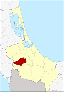
Amphoe Khlong Hoi Khong
|
Khlong Hoi Khong คลอง หอยโข่ง |
|
|---|---|
| Province: | Songkhla |
| Surface: | 275.2 km² |
| Residents: | 25,506 (2012) |
| Population density : | 85.4 U / km² |
| ZIP : | 90230, 90115, 90110 |
| Geocode : | 9016 |
| map | |

|
|
Amphoe Khlong Hoi Khong ( Thai : อำเภอ คลอง หอยโข่ง ) is a district ( amphoe - administrative district) in Songkhla Province . The Songkhla Province is located in the southern region of Thailand on the coast to the Gulf of Thailand .
geography
Neighboring districts and areas (clockwise from the north): Hat Yai and Sadao district in Songkhla Province and Khuan Kalong district in Satun Province .
history
Khlong Hoi Khong was initially set up as a subdistrict ( King Amphoe ) on April 1, 1992 , by separating the three tambon Khlong Hoi Khong, Khok Muang and Thung Lan from the Hat Yai district . On October 11, 1997, Khlong Hoi Khong was promoted to Amphoe.
traffic
Hat Yai International Airport is located in Amphoe Khlong Hoi Khlong .
administration
Provincial Administration
Amphoe Khlong Hoi Khong is divided into four sub-districts ( tambon ) , which are further subdivided into 32 village communities ( muban ) .
| No. | Surname | Thai | Muban | Pop. |
|---|---|---|---|---|
| 1. | Khlong Hoi Khong | คลอง หอยโข่ง | 7th | 6.225 |
| 2. | Thung Lan | ทุ่ง ลาน | 9 | 6,779 |
| 3. | Khok Muang | โคก ม่วง | 9 | 7,403 |
| 4th | Khlong La | คลอง หลา | 7th | 5,099 |
Local administration
There are two small towns ( Thesaban Tambon ) in the county:
- Thung Lan ( เทศบาล ตำบล ทุ่ง ลาน ) encompasses the entire tambon Thung Lan.
- Khok Muang ( เทศบาล ตำบล โคก ม่วง ) consists of the entire tambon Khok Muang.
The two tambon Khlong Hoi Khong and Khlong La are each administered by a "Tambon Administration Organization" (TAO, องค์การ บริหาร ส่วน ตำบล ).
Individual evidence
- ↑ ประกาศ กระทรวง มหาดไทย เรื่อง แบ่ง เขต ท้องที่ อำเภอ หาดใหญ่ จังหวัด สงขลา ตั้ง เป็น กิ่ง อำเภอ คลอง หอยโข่ง Royal Gazette, Volume 109, Issue 51 ง special ( ฉบับ พิเศษ ) of April 22, 1992, p. 10 (in Thai)
- ↑ พระราชกฤษฎีกา ตั้ง อำเภอ หนอง ปรือ อำเภอ ห้วย กระเจา อำเภอ ทราย ทอง วัฒนา อำเภอ ปาง ศิลา ทอง อำเภอ เนิน สง่า อำเภอ นา ทม อำเภอ พระ พรหม อำเภอ แม่ แม่ วงก์ อำเภอ สอง แคว อำเภอ บ้าน ใหม่ ไชย พจน์ อำเภอ ไทย เจริญ อำเภอ กา บัง อำเภอ พยุ จันทร์ อำเภอ เมือง เมือง เมือง เมือง เมือง เมือง เมือง ภู พาน อำเภอ คลอง หอยโข่ง อำเภอ เขา ฉกรรจ์ อำเภอ นา วัง อำเภอ พิบูลย์ รักษ์ และ อำเภอ ทุ่ง ศรี อุดม พ.ศ. ๒๕๔๐ Royal Gazette, Volume 114, Ed. 50 ก of September 26, 1997, pp. 24-27 (in Thai)
- ↑ Population statistics 2012 . Department of Provincial Administration. Retrieved July 13, 2014.
Web links
Coordinates: 6 ° 54 ' N , 100 ° 23' E
