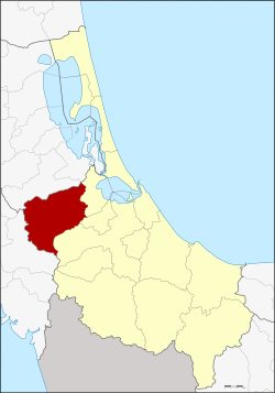
Amphoe Rattaphum
|
Rattaphum รัตภูมิ |
|
|---|---|
| Province: | Songkhla |
| Surface: | 591.8 km² |
| Residents: | 72,368 (2012) |
| Population density : | 114.8 U / km² |
| ZIP : | 90180, 90220 |
| Geocode : | 9009 |
| map | |

|
|
Amphoe Rattaphum ( Thai : อำเภอ รัตภูมิ ) is a county ( amphoe - administrative district) in Songkhla Province . The Songkhla Province is located in the east of the southern region of Thailand on the coast to the Gulf of Thailand .
geography
Neighboring districts and areas (clockwise from east): Khuan Niang , Bang Klam, and Hat Yai district in Songkhla Province, Khuan Kalong district in Satun Province, and Pa Bon district in Phatthalung Province .
history
The original name of the district was Kamphaeng Phet after the central tambon . In 1939 it was renamed Rattaphum.
administration
Provincial Administration
Amphoe Rattaphum is divided into five subdistricts ( tambon ) , which are further subdivided into 59 village communities ( muban ) .
| No. | Surname | Thai | Villages | Pop. |
|---|---|---|---|---|
| 1. | Kamphaeng Phet | กำแพงเพชร | 12 | 20,685 |
| 2. | Tha Chamuang | ท่า ชะมวง | 13 | 17,288 |
| 3. | Khuha Tai | คูหา ใต้ | 14th | 11,879 |
| 4th | Khuan Ru | ควน รู | 9 | 6,010 |
| 9. | Khao Phra | เขา พระ | 11 | 16,505 |
Note: the missing geocodes refer to the tambon that make up Amphoe Khuan Niang .
Local administration
There is a city ( Thesaban Mueang ) in the district:
- Kamphaeng Phet ( เทศบาล เมือง กำแพงเพชร ) consists of parts of the Tambon Kamphaeng Phet,
There are also three small towns ( Thesaban Tambon ) :
- Kamphaeng Phet ( เทศบาล ตำบล กำแพงเพชร ) consists of further parts of the Tambon Kamphaeng Phet.
- Na Si Thong ( เทศบาล ตำบล นา สี ทอง ) consists of parts of the Tambon Khao Phra.
- Khuha Tai ( เทศบาล ตำบล คูหา ใต้ ) consists of the whole tambon Khuha Tai.
There are also three “tambon administration organizations” (TAO, องค์การ บริหาร ส่วน ตำบล ) for the tambon or the parts of tambon in the county that do not belong to any town.
Individual evidence
- ↑ พระราชกฤษฎีกา เปลี่ยน นาม อำเภอ กิ่ง อำเภอ และ ตำบล บาง แห่ง พุทธศักราช ๒๔๘๒ Royal Gazette, Volume 56, Ed. 0 ก of April 17, 1939, pp. 354–364 (in Thai)
- ↑ Population statistics 2012 . Department of Provincial Administration. Retrieved July 13, 2014.
Web links
Coordinates: 7 ° 8 ' N , 100 ° 16' E
