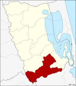
Amphoe Pa Bon
|
Pa Bon ป่า บอน |
|
|---|---|
| Province: | Phatthalung |
| Surface: | 380.844 km² |
| Residents: | 46,555 (2012) |
| Population density : | 115.5 U / km² |
| ZIP : | 93170 |
| Geocode : | 9308 |
| map | |

|
|
Amphoe Pa Bon ( Thai : อำเภอ ป่า บอน ) is a district ( amphoe - administrative district) in Phatthalung Province . Phatthalung Province is located in the southern region of Thailand , about 840 kilometers south of Bangkok on the Malay Peninsula .
geography
Neighboring districts and territories (from the north clockwise): Amphoe Tamot , Bang Kaeo and Pak Phayun in the province of Phatthalung Amphoe Rattaphum in Songkhla province and Amphoe Khuan Kalong of Satun province and Amphoe Palian of Trang province .
history
Pa Bon was initially set up as a subdistrict ( King Amphoe ) on May 1, 1983 , by separating the three tambon Pa Bon, Nong Thong and Khok Sai from Amphoe Pak Phayun . Pa Bon was promoted to Amphoe on May 21, 1990.
administration
Provincial Administration
Amphoe Pa Bon is divided into five subdistricts ( tambon ) , which are further subdivided into 48 village communities ( muban ) .
| No. | Surname | Thai | Muban | Pop. |
|---|---|---|---|---|
| 1. | Pa Bon | ป่า บอน | 10 | 9,738 |
| 2. | Khok Sai | โคก ทราย | 12 | 10,260 |
| 3. | Nong Thong | หนอง ธง | 9 | 9,815 |
| 4th | Thung Nari | ทุ่ง นารี | 9 | 9,647 |
| 6th | Wang Mai | วัง ใหม่ | 8th | 7,095 |
Note: Number (geocode) 5 is not used.
Local administration
Pa Bon ( เทศบาล ตำบล ป่า บอน ) is a small town ( Thesaban Tambon ) in the district, it consists of parts of the Tambon Pa Bon, Nong Thong and Wang Mai.
There are also five “tambon administration organizations” (TAO, องค์การ บริหาร ส่วน ตำบล ) for the tambon or the parts of tambon in the county that do not belong to any town.
Individual evidence
- ↑ ประกาศ กระทรวง มหาดไทย เรื่อง แบ่ง ท้องที่ อำเภอ ปากพะยูน จังหวัด พัทลุง ตั้ง เป็น กิ่ง อำเภอ ป่า บอน . In: Royal Gazette . 100, No. 65 ง , April 26, 1983, p. 1318.
- ↑ พระราชกฤษฎีกา ตั้ง อำเภอ ห้วย ผึ้ง อำเภอ วัง วิเศษ อำเภอ คลอง หาด อำเภอ ป่า บอน อำเภอ หนองหญ้าปล้อง อำเภอ วัง โป่ง อำเภอ ควน เนียง อำเภอ หนอง หนอง หญ้า ไซ อำเภอ บ้านนาเดิม อำเภอ ทุ่งฝน อำเภอ สร้างคอม และ อำเภอ ทอง แสน ขัน พ.ศ. ๒๕๓๓ . In: Royal Gazette . 107, No. 83 ก ฉบับ พิเศษ (special), May 21, 1994, pp. 1-4.
- ↑ Population statistics 2012 . Department of Provincial Administration. Retrieved July 11, 2014.
Web links
Coordinates: 7 ° 16 ' N , 100 ° 10' E