Amphoe Palian
|
Palian ปะเหลียน |
|
|---|---|
| Province: | Trang |
| Surface: | 973.13 km² |
| Residents: | 66,535 (2012) |
| Population density : | 64.7 U / km² |
| ZIP : | 92120, 92140, 92180 |
| Geocode : | 9204 |
| map | |

|
|
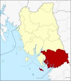
Palian district ( Thai : อำเภอ ปะเหลียน ) is a district ( Amphoe - administrative district) of Trang province . Trang Province is located in the southern region of Thailand .
geography
Palian County is in the south of the province.
Adjacent counties and areas are (from east clockwise): Amphoe Kong Ra , Tamot and Pa Bon of Phatthalung Province , Amphoe Khuan Kalong , Manang and Thung Wa of Satun Province and Hat Samran District and Yan Ta Khao District in the province of Trang .
Parts of the Mu Ko Phetra National Park are in the district.
history
Palian was originally called Yong Sata ( ห ยง ส ตา ). In 1939 it got its current name.
administration
Provincial Administration
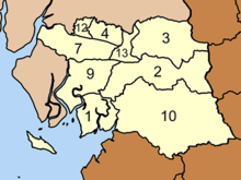
Amphoe Palian is divided into ten subdistricts ( tambon ) , which are further subdivided into 85 village communities ( muban ) .
|
The missing geocodes belong to the tambon that today Amphoe Hat Samran consists of.
Local administration
There are three small towns ( Thesaban Tambon ) in the county:
- Tha Kham ( เทศบาล ตำบล ท่า ข้าม ), consisting of parts of the Tambon Tha Kham.
- Thung Yao ( เทศบาล ตำบล ทุ่ง ยาว ), consisting of parts of the tambon Thung Yao.
- Tha Phaya ( เทศบาล ตำบล ท่า พญา ), consisting of the whole tambon Tha Phaya.
There are also nine "Tambon Administrative Organizations " ( องค์การ บริหาร ส่วน ตำบล - Tambon Administrative Organizations, TAO) for the Tambon or the parts of Tambon in the county that do not belong to any city.
Individual evidence
- ↑ พระราชกฤษฎีกา เปลี่ยน นาม อำเภอ กิ่ง อำเภอ และ ตำบล บาง แห่ง พุทธศักราช ๒๔๘๒ Royal Gazette, Volume 56, Ed. 0 ก of April 17, 1939, pp. 54–364 (in Thai)
- ↑ Population statistics 2012 . Department of Provincial Administration. Retrieved July 15, 2014.
Web links
- More details on Amphoe Palian from amphoe.com (in Thai)
- Palian County Council website (in Thai)
Coordinates: 7 ° 10 ' N , 99 ° 41' E


