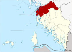
Amphoe Thung Wa
|
Thung Wa ทุ่งหว้า |
|
|---|---|
| Province: | Satun |
| Surface: | 452.33 km² |
| Residents: | 23,212 (2012) |
| Population density : | 45.75 U / km² |
| ZIP : | 91120 |
| Geocode : | 9106 |
| map | |

|
|
Amphoe Thung Wa ( Thai : อำเภอ ทุ่งหว้า ) is a district ( amphoe - administrative district) in Satun Province . The Satun Province is located in the extreme southwest of the southern region of Thailand on the west coast of the Malay Peninsula .
geography
Neighboring counties and areas are (clockwise from north): Amphoe Palian in Trang Province , Amphoe Manang and Amphoe La-ngu in Satun Province. To the west lies the Strait of Malacca .
A large part of the coast of the district as well as some offshore islands are part of the Mu Ko Phetra National Park .
history
Thung Wa was one of the original districts of the city ( Mueang ) Satun. The main line of business at the beginning of the 20th century was the production of pepper. When pepper production in Thung Wa declined in the 1910s, many locals moved to the agricultural district of La-ngu and foreign merchants left the area. In 1930, the government adapted the administration to the changed economic situation by upgrading La-ngu to a district and at the same time converting Thung Wa into a small district ( King Amphoe ) . 1973 Thung Wa was given amphoe status again.
administration
Provincial Administration
Amphoe Khuan Don is divided into five subdistricts ( tambon ) , which are further subdivided into 35 village communities ( muban ) .
| No. | Surname | Thai | Muban | Pop. |
|---|---|---|---|---|
| 1. | Thung Wa | ทุ่งหว้า | 10 | 7,052 |
| 2. | Well Thon | นา ทอน | 9 | 7,015 |
| 3. | Khon clan | ขอน คลาน | 4th | 2,650 |
| 4th | Thung Bulang | ทุ่ง บุ หลัง | 5 | 2,289 |
| 5. | Pakae Bohin | ป่า แก่ บ่อ หิน | 7th | 4,206 |
Local administration
Thung Wa ( เทศบาล ตำบล ทุ่งหว้า ) is a small town ( Thesaban Tambon ) in the district, it consists of parts of the Tambon Thung Wa.
There are also five “tambon administration organizations” (TAO, องค์การ บริหาร ส่วน ตำบล ) for the tambon or the parts of tambon in the county that do not belong to any town.
Individual evidence
- ↑ ประกาศ กระทรวง มหาดไทย เรื่อง ย้าย สับเปลี่ยน ที่ว่าการ อำเภอ . In: Royal Gazette . 47, No. 0 ก , September 14, 1930, p. 193.
- ↑ พระราชกฤษฎีกา ตั้ง อำเภอ เขาพนม อำเภอ สนามชัยเขต อำเภอ แม่อาย อำเภอ ขามสะแกแสง อำเภอ เก้าเลี้ยว อำเภอ โพธิ์ประทับช้าง อำเภอ หนองพอก อำเภอ ละอุ่น อำเภอ ทุ่งหว้า และ อำเภอ ศรีธาตุ พ.ศ. ๒๕๑๖ Royal Gazette, Volume 90, Edition 75 ก special ( ฉบับ พิเศษ ) from June 28, 1973, pp. 32–36 (in Thai)
- ↑ Population statistics 2012 . Department of Provincial Administration. Retrieved July 13, 2014.
Web links
Coordinates: 7 ° 7 ' N , 99 ° 45' E
