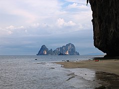
Mu Ko Phetra National Park
| Mu Ko Phetra National Park | ||
|---|---|---|
| View of Koh Phetra from Koh Lao Liang Nuea | ||
|
|
||
| Location: | Satun , Thailand | |
| Next city: | Songkhla | |
| Surface: | 494.38 km² | |
| Founding: | December 31, 1984 | |
| Koh Lao Liang Tai | ||
Mu Ko Phetra ( Thai : อุทยานแห่งชาติ หมู่ เกาะ เภตรา ) is a marine national park at the junction of the Strait of Malacca into the Andaman Sea , in southern Thailand .
Geography and terns
The Mu-Ko-Phetra National Park consists of largely intact coastlines, open sea and around 30 islands in both the northern part of Satun Province and the southern part of Trang Province . It opened on December 31, 1984 as the 49th National Park and the 14th Marine National Park of Thailand.
Most of the park (about 94.74 percent of the total 494.38 km²) is open water. The park's two largest islands are Koh Phetra ( เกาะ เภตรา ), from which the park takes its name, and Koh Khao Yai ( เกาะ เขา ใหญ่ ). Endangered sea turtles lay their eggs on many of the islands in the park . In many places there is still a coral reef . Some islands only have small beaches, but rugged limestone formations .
A species of tern breeds in the caves in the limestone cliffs , and their nests are famous among gourmets. They are harvested by agile men who have to shimmy along the cave ceilings over adventurous scaffolding. Since the swallow nests can fetch a very high price on the market, the islands are protected by armed guards.
Islands of Trang Province
- Ko Lao Liang - actually two separate islands 300 m apart: Ko Lao Liang Nuea ( เกาะ เหลา เห ลี ยง เหนือ , also Ko Lao Liang Nong เกาะ เหลา เห ลี ยง น้อง ) the somewhat smaller "northern" island and Ko Lao Liang Tai ( เกาะ เหลา เห ลี ยง ใต้ , also Ko Lao Liang Phi เกาะ เหลา เห ลี ยง พี่ ) the somewhat larger "southern" island. Both have only very small beaches and a few caves where swallow nests are harvested. Around the island, shallow reefs invite you to snorkel .
Islands of Satun Province
- Ko Phetra ( เกาะ เภตรา ) - an island with strangely shaped limestone cliffs, in which there are many guarded nesting holes of terns. The waters around the island are popular diving spots.
- Koh Lidi ( เกาะ ลิ ดี ) - quite a large island with a beach. There is an office of the National Park Ranger here, camping is possible.
- Koh Khao Yai ( เกาะ เขา ใหญ่ ) - the largest island with castle-like limestone rock formations. Part of the island is the Ao Kam Poo ( อ่าว ก้ามปู ), an approximately 700 m wide bay with a waterfall and a river. This is where the sea turtles come to lay their eggs.
- Koh Bulon ( เกาะ บุ โหลน ) - a very beautiful island with crystal clear water and a coral reef, very popular with (Thai) tourists.
Beaches in Satun
- Rawai Beach ( หาด รา ไว ) - not to be confused with the beach of the same name on the island of Phuket . It is about 3.5 km long and is located on the mainland. It is very popular with Thai tourists as a campsite.
Web links
- Mu Ko Phetra National Park by the Thai Department of National Parks - description in English [last accessed on October 15, 2013]


