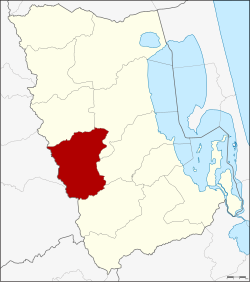
Amphoe Kong Ra
|
Kong Ra กงหรา |
|
|---|---|
| Province: | Phatthalung |
| Surface: | 255.856 km² |
| Residents: | 35,225 (2012) |
| Population density : | 130.6 U / km² |
| ZIP : | 93180, 93000 |
| Geocode : | 9302 |
| map | |

|
|
Amphoe Kong Ra ( Thai : อำเภอ กงหรา ) is a district ( amphoe - administrative district) in Phatthalung Province . Phatthalung Province is located in the southern region of Thailand , about 840 kilometers south of Bangkok on the Malay Peninsula .
geography
Neighboring districts and areas (clockwise from north): Amphoe Srinagarindra , Mueang Phatthalung , Khao Chaison and Tamot in Phatthalung Province and Amphoe Palian and Yan Ta Khao in Trang Province .
history
Kong Ra was initially set up as a subdistrict ( King Amphoe ) on October 1, 1975 when the tambon Kong Ra, Khlong Chaloem and Charat were separated from the Amphoe Mueang Phatthalung . On July 13, 1981, Kong Ra was promoted to Amphoe.
administration
Provincial Administration
Amphoe Kong Ra is divided into five subdistricts ( tambon ) , which are further subdivided into 45 village communities ( muban ) .
| No. | Surname | Thai | Muban | Pop. |
|---|---|---|---|---|
| 1. | Kong Ra | กงหรา | 7th | 4.137 |
| 2. | Charat | ชะ รัด | 9 | 6,955 |
| 3. | Khlong Chaloem | คลอง เฉลิม | 14th | 13,042 |
| 4th | Khlong Sai Khao | คลอง ทรายขาว | 8th | 6,501 |
| 5. | Som Wang | สมหวัง | 7th | 4,590 |
Local administration
There are four small towns ( Thesaban Tambon ) in the county:
- Charat ( เทศบาล ตำบล ชะ รัต ) consists of the entire tambon Charat.
- Kong Ra ( เทศบาล ตำบล กงหรา ) consists of the entire tambon Kong Ra.
- Khlong Sai Khao ( เทศบาล ตำบล คลอง ทรายขาว ) consists of the entire Tambon Khlong Sai Khao.
- Som Wang ( เทศบาล ตำบล สมหวัง ) consists of the entire tambon Som Wang.
Tambon Khlong Chaloem is administered by a "Tambon Administrative Organization" (TAO, องค์การ บริหาร ส่วน ตำบล ).
Individual evidence
- ↑ ประกาศ กระทรวง มหาดไทย เรื่อง แบ่ง ท้องที่ อำเภอ เมือง พัทลุง จังหวัด พัทลุง ตั้ง เป็น กิ่ง อำเภอ กงหรา . In: Royal Gazette . 92, No. 202 ง , September 13, 1975, p. 2411.
- ↑ พระราชกฤษฎีกา ตั้ง อำเภอ หนองใหญ่ อำเภอ บ่อไร่ อำเภอ พรหมคีรี อำเภอ นาบอน อำเภอ บางสะพาน น้อย อำเภอ นาดี อำเภอ กงหรา อำเภอ วังทรายพูน อำเภอ ธารโต อำเภอ คำตากล้า อำเภอ อำเภอ ศรีนคร อำเภอ ด่านช้าง อำเภอ พรเจริญ อำเภอ วังสามหมอ และ อำเภอ ลานสัก พ.ศ. ๒๕๒๔ . In: Royal Gazette . 98, No. 115 ก ฉบับ พิเศษ (special), July 13, 1981, pp. 7-10.
- ↑ Population statistics 2012 . Department of Provincial Administration. Retrieved July 11, 2014.
Web links
Coordinates: 7 ° 24 ' N , 99 ° 57' E