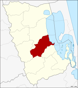
Amphoe Khao Chaison
|
Khao Chaison เขาชัยสน |
|
|---|---|
| Province: | Phatthalung |
| Surface: | 260.1 km² |
| Residents: | 44,384 (2012) |
| Population density : | 166.4 U / km² |
| ZIP : | 93130 |
| Geocode : | 9303 |
| map | |

|
|
Amphoe Khao Chaison ( Thai : อำเภอ เขาชัยสน ) is a district ( Amphoe - administrative district) in Phatthalung Province . The Phatthalung Province is located in the southern region of Thailand , about 840 km south of Bangkok on the Malay Peninsula .
geography
Neighboring districts and areas (clockwise from south): Amphoe Bang Kaeo , Tamot , Kong Ra and Mueang Phatthalung in Phatthalung Province and Amphoe Krasae Sin in Songkhla Province .
The east of the district lies on the banks of the Thale Luang lake .
history
Khao Chaison was first established in 1923 as a subdistrict ( King Amphoe ) Lampam ( ลำปำ ) as part of Mueang Phatthalung. It consisted of the two communities Lampam and Han Po. On November 1, 1939, the communities of Lampam, Phaya Khan and Khuan Maphrao were again directly subordinated to the Mueang District, while Khao Chaison and Khuan Khanun of the Mueang District as well as Tha Duea and Chong Thanon of Pak Phayun were assigned to the subdistrict. At the same time, the administration was also moved to Khao Chaison. In 1940 the Khao Chaison subdistrict was renamed after the central tambon . On January 1, 1953, Khao Chaison was promoted to Amphoe.
administration
Provincial Administration
Khao Chaison is divided into five subdistricts ( tambon ) , which are further subdivided into 56 village communities ( muban ) .
| No. | Surname | Thai | Muban | Pop. |
|---|---|---|---|---|
| 1. | Khao Chaison | เขาชัยสน | 14th | 13,560 |
| 2. | Khuan Khanun | ควนขนุน | 10 | 8,411 |
| 5. | Chong Thanon | จองถนน | 7th | 3,620 |
| 6th | Han Pho | หา น โพธิ์ | 11 | 8,577 |
| 7th | Khok Muang | โคก ม่วง | 14th | 10,216 |
Note: the missing numbers (geocodes) refer to the tambon that make up Amphoe Bang Kaeo .
Local administration
There are three small towns ( Thesaban Tambon ) in the county:
- Khao Chaison ( เทศบาล ตำบล เขาชัยสน ) consists of parts of the Tambon Khao Chaison.
- Khok Muang ( เทศบาล ตำบล โคก ม่วง ) consists of the entire tambon Khok Muang.
- Chong Thanon ( เทศบาล ตำบล จองถนน ) consists of the entire Tambon Chong Thanon.
There are also three “tambon administration organizations” (TAO, องค์การ บริหาร ส่วน ตำบล ) for the tambon or the parts of tambon in the county that do not belong to any town.
Individual evidence
- ↑ ประกาศ กระทรวง มหาดไทย เรื่อง เปลี่ยนแปลง เขต อำเภอ และ กิ่ง อำเภอ จังหวัด พัทลุง . In: Royal Gazette . 56, No. 0 ง , November 6, 1939, pp. 2379-2380.
- ↑ ประกาศ กระทรวง มหาดไทย เรื่อง ย้าย ที่ว่าการ กิ่ง อำเภอ ลำ ป่า จังหวัด พัทลุง . In: Royal Gazette . 56, No. 0 ง , November 6, 1939, pp. 2378-2379.
- ↑ พระราชกฤษฎีกา เปลี่ยน นาม อำเภอ กิ่ง อำเภอ และ ตำบล บาง แห่ง พุทธศักราช ๒๔๘๓ . In: Royal Gazette . 57, No. 0 ก , April 30, 1940, pp. 53-55.
- ↑ พระราชกฤษฎีกา จัดตั้ง อำเภอ จักราช อำเภอ สัต ต หีบ อำเภอ ศรีสงคราม อำเภอ ชะอวด อำเภอ หนองแซง อำเภอ ภาชี อำเภอ เขา ไชย สน อำเภอ ชุมพลบุรี อำเภอ วาริชภูมิ อำเภอ สบปราบ สบปราบ และ อำเภอ สุไหงโกลก พ.ศ. ๒๔๙๖ . In: Royal Gazette . 70, No. 17 ก , March 10, 1953, pp. 368-371.
- ↑ Population statistics 2012 . Department of Provincial Administration. Retrieved July 11, 2014.
Web links
Coordinates: 7 ° 28 ' N , 100 ° 8' E