
Amphoe Kantang
|
Kantang กันตัง |
|
|---|---|
| Province: | Trang |
| Surface: | 612.7 km² |
| Residents: | 86,326 (2012) |
| Population density : | 135.5 U / km² |
| ZIP : | 92110 |
| Geocode : | 9202 |
| map | |

|
|
Kantang district ( Thai อำเภอ กันตัง ) is a district ( Amphoe - administrative district) of Trang province . Trang Province is located in the southern region of Thailand .
geography
Kantang County is in the west of the province. The mouth of the Khlong Trang is in the district.
Neighboring districts (clockwise from north): Sikao District , Mueang Trang, and Yan Ta Khao District of Trang Province. In the southwest is the Andaman Sea .
history
Kantang was originally the capital of Trang Province. The provincial administration was initially in Khuan Thani, then from 1893 to 1916 directly on the coast in Kantang . However, since there were regular floods there, the capital was moved further inland to its current position. The city pillar ( Lak Mueang ) of Trang, however, is still in Khuan Thani today.
traffic
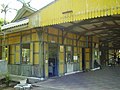
The Thung Song Junction – Kantang railway ends in the city of Kantang , a branch of the Southern Railway connecting Bangkok with Malaysia .

View from the tracks

Entrance from the street
View of the platform

Detail of old objects


Attractions
- Hat Yong Lin ( หาด ห ยง หลิน ) - small flat sandy beach, lined with limestone cliffs
- National parks:
- Hat Chao Mai National Park ( อุทยาน นก น้ำ คลอง นำ ชาน ) - the 230.86 km² park has existed since 1981. It consists of part of the Kantang coastline and numerous islands, such as Ko Muk ( เกาะ มุก ) and Ko Kradan ( เกาะ กระดาน ). On the mainland near the park administration there is a spring with water at around 70 ° C.
- Water falls:
- Outside the national park there are some waterfalls that are worth seeing, such as the Sai-Rung waterfall ( น้ำตก สายรุ้ง ), the Ka-Chong waterfall ( น้ำตก กะ ช่อง ) and the Lam-Plok waterfall ( น้ำตก ลำ ปลอก ).
administration
Provincial Administration
Amphoe Kantang is divided into 14 communities ( Tambon ) , which in turn are divided into 83 villages ( Muban ) .
|

Local administration
Kantang ( เทศบาล เมือง กันตัง ) is a city ( Thesaban Mueang ) in the district, it consists of the entire Tambon Kantang.
There are also 13 "Tambon Administrative Organizations " ( องค์การ บริหาร ส่วน ตำบล - Tambon Administrative Organizations, TAO) for the tambon in the county that do not belong to any city.
Web links
- More details on Amphoe Kantang from amphoe.com (in Thai)
- Hat Chao Mai National Park (Information from the Thai National Park Administration - in English)
Individual evidence
- ↑ Population statistics 2012 . Department of Provincial Administration. Retrieved July 15, 2014.

Mueang Trang | Kantang | Yan Ta Khao | Palian | Sikao | Huai Yot | Wang Wiset | Na Yong | Ratsada | Has Samran
Coordinates: 7 ° 24 ' N , 99 ° 31' E