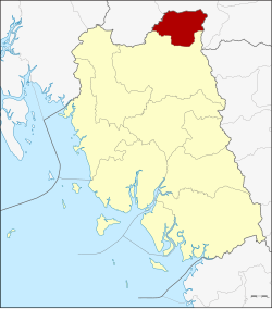
Ratsada district
|
Ratsada รั ษ ฎา |
|
|---|---|
| Province: | Trang |
| Surface: | 232.4 km² |
| Residents: | 28,489 (2012) |
| Population density : | 113.5 U / km² |
| ZIP : | 92160, 92130 |
| Geocode : | 9209 |
| map | |

|
|
Amphoe Ratsada ( Thai : อำเภอ รั ษ ฎา ) is a district ( Amphoe - administrative district) in the northeast of Trang Province . Trang Province is located in the southern region of Thailand .
geography
Adjacent counties and areas are (from south clockwise) Huai Yot District in the province of Trang and the Amphoe Bang Khan and Thung Song of the province of Nakhon Si Thammarat .
history
Ratsada was initially set up as a small district ( King Amphoe ) on April 1, 1991 by separating five tambon from the Huai Yot district . On December 5, 1996, Ratsada was granted full amphoe status.
administration
Provincial Administration
Amphoe Ratsada is divided into five subdistricts ( tambon ) , which are further subdivided into 50 village communities ( muban ) .
|
Local administration
Khlong Pang ( เทศบาล ตำบล คลอง ปาง ) is a small town ( Thesaban Tambon ) in the district, it consists of parts of the Tambon Khlong Pang.
There are also five "Tambon Administrative Organizations " ( องค์การ บริหาร ส่วน ตำบล - Tambon Administrative Organizations, TAO) for the Tambon or the parts of Tambon in the county that do not belong to any city.
Individual evidence
- ↑ ประกาศ กระทรวง มหาดไทย เรื่อง แบ่ง เขต ท้องที่ อำเภอ ห้วยยอด จังหวัด ตรัง ตั้ง เป็น กิ่ง อำเภอ รั ษ ฎา Royal Gazette, Volume 108, Ed. 15 ง of January 31, 1991, p. 1071 (in Thai)
- ↑ พระราชกฤษฎีกา ตั้ง อำเภอ เหนือ คลอง อำเภอ นา ยาย อาม อำเภอ ท่า ตะเกียบ อำเภอ ขุน ตาล อำเภอ แม่ ฟ้า หลวง อำเภอ แม่ ลาว อำเภอ รั ษ ฎา อำเภอ อำเภอ พุทธ มณฑล อำเภอ วัง วัง น้ำ เขียว อำเภอ เจาะ ไอ ร้อง อำเภอ ชำนิ อำเภอ โนน ดินแดง อำเภอ ปาง สนธิ อำเภอ อำเภอ อำเภอ อำเภอ อำเภอ อำเภอ อำเภอ หนอง ม่วง อำเภอ เบญจ ลัก ษ์ อำเภอ โพน นา แก้ว อำเภอ บุ่ง คล้า อำเภอ ดอน มดแดง และ อำเภอ ลือ อำนาจ พ.ศ. ๒๕๓๙ Royal Gazette, Volume 113, Ed. 62 ก November 20, 1996 pp. 5–8 (in Thai)
- ↑ Population statistics 2012 . Department of Provincial Administration. Retrieved July 15, 2014.
Web links
- More details on Amphoe Ratsada from amphoe.com (in Thai)
- Ratsada District Administration (in Thai)
Coordinates: 7 ° 58 ' N , 99 ° 38' E

