Montdardier
| Montdardier | ||
|---|---|---|

|
|
|
| region | Occitania | |
| Department | Gard | |
| Arrondissement | Le Vigan | |
| Canton | Le Vigan | |
| Community association | Pays Viganais | |
| Coordinates | 43 ° 56 ' N , 3 ° 36' E | |
| height | 259-889 m | |
| surface | 35.25 km 2 | |
| Residents | 201 (January 1, 2017) | |
| Population density | 6 inhabitants / km 2 | |
| Post Code | 30120 | |
| INSEE code | 30176 | |
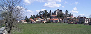
 View of Montdardier |
||
Montdardier is a French commune with 201 inhabitants (as of January 1, 2017), located in the Gard department and in the Occitanie region . It belongs to the Arrondissement of Le Vigan and the Canton of Le Vigan . The place is a member of the Communauté de communes du Pays Viganais. The residents call themselves Montdardiérins or Montdardiérines .
Montdardier is on the Camino de Santiago to Santiago de Compostela .
geography
Montdardier is located in the south of France at an altitude between 259 and 889 m , the place itself is located at approx. 615 m . The municipality covers a total of 3,525 hectares (35.25 km²). The place is located directly on the department road D48, which leads in north-south direction from Le Vigan to Lodève . The D48 runs on the path of an old Roman road that connected the Cevennes with Spain . Montdardier is located in the Parc National des Cévennes, from here small back roads lead into the park.
The place is on the edge of the Causse de Blandas , the village dominates the valley and the old Roman road.
history
It was first mentioned as Montis Disderii in 1077. The hill on which the place is located dominates the old Roman road from Le Vigan to Lodève. The first fortress was built here in the 12th century, and there is now a neo-Gothic style castle. A first hospital for pilgrims on the Camino de Santiago was founded by the Knights Templar.
In 1469, Montdardier was hit in the subsequent battles of the Ligue du Bien public , the village and the castle were damaged.
The place was badly damaged again in the wars of religion. The church and castle were destroyed when troops from the Duke of Rohan attacked the site. In 1792 the castle burned down and was renovated after the revolution. The village then extended beyond the fortifications and became a mountain village.
Economy and Infrastructure
An important line of business at the end of the 19th century was mining in the mines of Malines, where lead, zinc and barite were mined. Agriculture and forestry now dominate. Black pine, cedar, birch and willow are felled in forestry. In addition to sheep breeding, llamas are also raised.
Population development
The population of Montdardier developed inconspicuously from 1793 until after 1886. In the next 20 years the population doubled, in 1906 the highest number of inhabitants was reached with 1,051. Since then, with the closure of the mines and the general rural exodus in the course of the twentieth century, the number of inhabitants has continuously decreased.
| 1962 | 1968 | 1975 | 1982 | 1990 | 1999 | 2008 | 2017 |
|---|---|---|---|---|---|---|---|
| 273 | 215 | 197 | 178 | 157 | 187 | 193 | 201 |
Trivia
The 2006 Rallye des Cévennes took place on the back roads around Montdardier .
