
L'Estréchure
|
L'Estréchure L'Estrechura |
||
|---|---|---|
.svg)
|
|
|
| region | Occitania | |
| Department | Gard | |
| Arrondissement | Le Vigan | |
| Canton | Le Vigan | |
| Community association | Causses Aigoual Cevennes | |
| Coordinates | 44 ° 7 ' N , 3 ° 47' E | |
| height | 271-1,166 m | |
| surface | 19.34 km 2 | |
| Residents | 161 (January 1, 2017) | |
| Population density | 8 inhabitants / km 2 | |
| Post Code | 30124 | |
| INSEE code | 30108 | |
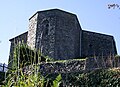
 L'Estréchure - Church ( Saint-Martin de Corconac ) |
||

L'Estréchure ( Occitan L'Estrechura ) is a place and a municipality with 161 inhabitants (as of January 1, 2017) in the southern French department of Gard .
location
L'Estréchure is located on the upper reaches of the Gardon approx. 44 km (driving distance) northeast of the canton capital Le Vigan in the southern foothills of the Cevennes at an altitude of approx. 305 m above sea level. d. M. Closest large cities are Nîmes (approx. 70 km southeast) and Montpellier (approx. 78 km south). The climate is temperate; Rain falls throughout the year.
Population development
| year | 1800 | 1851 | 1901 | 1954 | 1999 | 2014 |
| Residents | 464 | 611 | 571 | 295 | 143 | 163 |
The continuous decline in the number of inhabitants since the middle of the 19th century is essentially due to the mechanization of agriculture and the associated loss of jobs. In addition, almost all mountain regions in France depopulated in favor of the cities in the valleys.
economy
For centuries, the residents of the community lived as a self-sufficient source of agriculture and livestock (sheep, goats) and the numerous sweet chestnuts in the surrounding forests. In the years 1910 and 1913, two silk spinning mills, which no longer exist, were founded. Today tourism is important in the form of renting holiday homes ( gîtes ).
history
In the Middle Ages, the hamlet of Estrechour was part of the parish of Saint-Martin de Corconac , which, however, perished in the turmoil of the Huguenot Wars (1562–1598) and later religiously motivated conflicts and only existed in name at the time of the French Revolution ; only the former parish church is still preserved.
Attractions
- The place was created at a narrow point ( estrechour ) of the Gardon.
- The Protestant church ( temple ) of the place has a comparatively elaborate portal and a simple bell gable .
- Two wells still supply potable spring water .
- outside
- The approximately two kilometers southeast location, and (of unhewn stone slabs schistes ) Built former parish church of Saint-Martin de Corconac ( 44 ° 6 '9 " N , 3 ° 48' 1" O ) was created in the 12th century; Parts of the west facade and the north wall of the nave are still preserved from this time . In the 14th century, a new, polygonally broken choir section and a new aisle on the south side were built. The privately owned church building was declared a monument historique in 2012 .
Choir part

West facade

Gothic window

Church interior


Web links
- L'Estréchure - Photos + Info (French)
Individual evidence
- ↑ L'Estréchure - Map with altitude information
- ↑ Anduze / L'Estréchure - climate tables
- ↑ L'Estréchure - Ancienne église Saint-Martin-de-Corconac in the Base Mérimée of the French Ministry of Culture (French)