Fressac
| Fressac | ||
|---|---|---|

|
|
|
| region | Occitania | |
| Department | Gard | |
| Arrondissement | Le Vigan | |
| Canton | Quissac | |
| Community association | Piémont Cévenol | |
| Coordinates | 44 ° 0 ′ N , 3 ° 56 ′ E | |
| height | 184-348 m | |
| surface | 5.89 km 2 | |
| Residents | 162 (January 1, 2017) | |
| Population density | 28 inhabitants / km 2 | |
| Post Code | 30170 | |
| INSEE code | 30119 | |
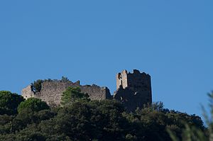
 Fressac - Ruins of the Château de Fressac |
||
Fressac is a place and a municipality with 162 inhabitants (as of January 1, 2017) in the southern French department of Gard .
location
Fressac is located on the upper reaches of the Conturby approx. 14 km (driving distance) northwest of the canton capital Quissac in the southern foothills of the Cevennes at an altitude of approx. 210 m above sea level. d. M. The closest major city is Montpellier (approx. 59 km south). The climate is temperate; Rain falls throughout the year.
Population development
| year | 1800 | 1851 | 1901 | 1954 | 1999 | 2017 |
| Residents | 129 | 120 | 98 | 69 | 87 | 162 |
The continuous decline in the number of inhabitants since the middle of the 19th century is essentially due to the mechanization of agriculture and the associated loss of jobs. In addition, almost all mountain regions in France depopulated in favor of the cities in the valleys. This development only came to a standstill in the 1990s when some new settlers from Quissac and the surrounding area settled here.
economy
For centuries, the residents of the community lived on a self-sufficient basis by farming and raising livestock (sheep, goats). Today forestry and tourism are important.
history
The castle of Fressac was of strategic importance both in the Huguenot Wars (1562–1598) and in the Camisard Revolt (1702–1704).
Attractions
- The former castle ( Château de Fressac ), located about one and a half kilometers southwest of the town on an approximately 100 meter high hill, was built in the 13th century and was inhabited for about 450 years. Most recently it played a role as a royal fortress during the Camisard Uprising (1702–1704). The ruined castle with its imposing castle keep ( donjon ) was built in 1992 on historique Monument explained.
- Fossil traces of ammonites etc. can be found in a rock slab near the bridge over the Conturby River .
Web links
Individual evidence
- ↑ Fressac - map with altitude information
- ↑ Quissac / Fressac - climate tables
- ↑ Fressac - Château
- ↑ Fressac - Château in the Base Mérimée of the French Ministry of Culture (French)

