Trèves (Gard)
| Treves | ||
|---|---|---|

|
|
|
| region | Occitania | |
| Department | Gard | |
| Arrondissement | Le Vigan | |
| Canton | Le Vigan | |
| Community association | Causses Aigoual Cevennes | |
| Coordinates | 44 ° 5 ' N , 3 ° 23' E | |
| height | 514-1,282 m | |
| surface | 26.59 km 2 | |
| Residents | 128 (January 1, 2017) | |
| Population density | 5 inhabitants / km 2 | |
| Post Code | 30750 | |
| INSEE code | 30332 | |
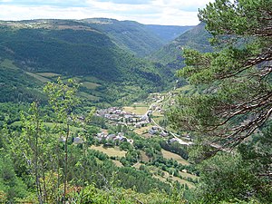
 View from the mountains to Trèves |
||
Trèves is a French commune with 128 inhabitants (as of January 1, 2017) in the Gard department in the Occitanie region . It belongs to the canton of Le Vigan and to the community association Communauté de communes Causses Aigoual Cévennes .
geography
Trèves is located in the west of the department in the Cevennes National Park on the edge of the Causse Noir in the valley of the Trèvezel , a tributary of the Dourbie , 65 kilometers northwest of Montpellier , 25 kilometers southeast of Millau and 16 kilometers west of Mont Aigoual , between the neighboring communities of Dourbies in the southeast, Causse-Bégon in the southwest and Lanuéjols in the north.
history
From the Middle Ages until 1790 Trèves was part of the Viguerie of Le Vigan and Meyrueis . In the census of 1384 Trèves was counted along with the commune of Revens , 7.4 kilometers to the west . Data from 1435 suggest that in 1384 no more than three Feux (literally “hearth fire”), ie three families, lived in Trèves.
Population development
| year | 1962 | 1968 | 1975 | 1982 | 1990 | 1999 | 2009 | 2017 |
| Residents | 169 | 151 | 139 | 129 | 120 | 119 | 110 | 120 |
| Sources: Cassini and INSEE | ||||||||
coat of arms
Since 1694, the town's coat of arms has been blue with a horizontal golden band in the middle and three upright silver axes, two of which are at the top and one at the top. In the heraldic color scheme , the metallic colors gold and silver are shown in yellow and white.
Attractions
The old bridge at Trèves was built in the 16th or 17th centuries on the ruins of an older bridge. A cross from the 17th century stands on its parapet. The bridge belongs to the municipality and was entered in the supplementary directory of the Monuments historiques (historical monuments) in 1931 .
The prehistoric cave of Le Pas-de-Joulié is partly located in the municipality. It shows traces of settlement from the Neolithic Age and a necropolis from the Copper Age . It is owned by the state and was classified as a Monument historique in 1953.
Web links
Individual evidence
- ↑ Trèves on annuaire-mairie.fr (French). Retrieved January 30, 2010
- ^ Trèves in the Base Mérimée des Ministère de la culture (French). Accessed January 30, 2010
