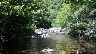
Trèvezel
| Trèvezel | ||
|
Upper course |
||
| Data | ||
| Water code | FR : O33-0430 | |
| location | France , Occitania region | |
| River system | Garonne | |
| Drain over | Dourbie → Tarn → Garonne → Atlantic Ocean | |
| source | in the northern municipality of Saint-Sauveur-Camprieu, 44 ° 5 ′ 58 ″ N , 3 ° 32 ′ 17 ″ E |
|
| Source height | approx. 1295 m | |
| muzzle | in place Cantobre , in the municipality of Nant in the Dourbie coordinates: 44 ° 3 '38 " N , 3 ° 18' 7" O 44 ° 3 '38 " N , 3 ° 18' 7" O |
|
| Mouth height | approx. 444 m | |
| Height difference | approx. 851 m | |
| Bottom slope | approx. 28 ‰ | |
| length | 30 km | |
| Right tributaries | Bramabiau | |
The Trèvezel is a river in France that runs in the Occitania region . It rises in the Cevennes National Park , in the municipality of Saint-Sauveur-Camprieu , generally drains west to southwest, enters the Grands Causses Regional Nature Park in its lower reaches and flows into the river after 30 kilometers at Cantobre , in the municipality of Nant , as a right tributary Dourbie . The Trèvezel crosses the Gard and Aveyron departments on its way .
Places on the river
- Saint-Sauveur-Camprieu
- Treves
- Cantobre , parish of Nant
Attractions
- The Grandes Gorges du Trèvezel are an impressive deep canyon.
- The lower reaches of the Grandes Gorges du Trèvezel are interesting kayaking waters.
Web links
Commons : Trèvezel - Collection of Images
