Hua Sai district
|
Hua Sai หัวไทร |
|
|---|---|
| Province: | Nakhon Si Thammarat |
| Surface: | 417.733 km² |
| Residents: | 66,912 (2012) |
| Population density : | 164.8 U / km² |
| ZIP : | 80170 |
| Geocode : | 8016 |
| map | |

|
|
Amphoe Hua Sai ( Thai : อำเภอ หัวไทร ) is a district ( Amphoe - administrative district) in the southeast of the province of Nakhon Si Thammarat . The province of Nakhon Si Thammarat is located in the southern region of Thailand , about 780 km south of Bangkok on the east coast of the Malay Peninsula to the Gulf of Thailand .
geography
Neighboring districts (clockwise from south): Ranot District in Songkhla Province , Khuan Khanun and Pa Phayom District in Phatthalung Province, and Cha-uat , Chian Yai and Pak Phanang District in Nakhon Si Thammarat Province. To the east lies the Gulf of Thailand .
history
Hua Sai was initially set up in 1904 under the name Khao Phang Krai ( เขา พัง ไกร ), the name arose from the central tambon Khao Phang Krai, in which the administration was located. When the administration building was relocated to Tambon Hua Sai in 1906 , the district got its current name. In 1924 the district was downgraded to a subdistrict ( King Amphoe ) under the administration of Amphoe Pak Phanang . In the same year, the administration was relocated to its current location in Muu 8 of Tambon Hua Sai. In 1937, Hua Sai was promoted to Amphoe.
administration
Provincial Administration
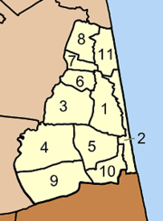
Amphoe Hua Sai is divided into eleven communities ( tambon ) , which in turn are divided into 99 villages ( muban ) .
|
Local administration
There are three small towns ( Thesaban Tambon ) in the county:
- Hua Sai ( เทศบาล ตำบล หัวไทร ) consists of parts of the Tambon Hua Sai and Na Saton.
- Ko Phet ( เทศบาล ตำบล เกาะ เพชร ) consists of the whole tambon Ko Phet.
- Na Saton ( เทศบาล ตำบล หน้า ส ตน ) consists of further parts of the Tambon Na Saton.
There are also nine “tambon administrative organizations” (TAO, องค์การ บริหาร ส่วน ตำบล ) for the tambon or the parts of tambon in the county that do not belong to any town.
Individual evidence
- ↑ ประกาศ สำนัก นายกรัฐมนตรี เรื่อง ตั้ง อำเภอ หัวไทร จังหวัด นครศรีธรรมราช . In: Royal Gazette . 54, No. 0 ง , August 2, 1937, pp. 850-851.
- ↑ Population statistics 2012 . Department of Provincial Administration. Retrieved July 7, 2014.
Web links
Coordinates: 8 ° 2 ′ N , 100 ° 17 ′ E

