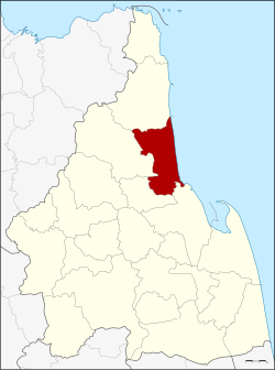
Amphoe Tha Sala
|
Tha Sala ท่าศาลา |
|
|---|---|
| Province: | Nakhon Si Thammarat |
| Surface: | 363.891 km² |
| Residents: | 110,327 (2012) |
| Population density : | 293.9 U / km² |
| ZIP : | 80160 |
| Geocode : | 8008 |
| map | |

|
|
Amphoe Tha Sala ( Thai : อำเภอ ท่าศาลา ) is a district ( Amphoe - administrative district) in the province of Nakhon Si Thammarat . The province of Nakhon Si Thammarat is located in the southern region of Thailand , about 780 km south of Bangkok on the east coast of the Malay Peninsula to the Gulf of Thailand .
geography
Neighboring districts (clockwise from the south): the Amphoe Mueang Nakhon Si Thammarat , Phrom Khiri , Nopphitam and Sichon . All Amphoe are in Nakhon Si Thammarat Province. To the east lies the Gulf of Thailand .
history
During the thesaphiban administrative reform, five mueang of the kingdom of Nakhon Si Thammarat were amalgamated to form this district of the Nakhon Si Thammarat province. These mueang were Thai Buri, Ron Ka Ro, Klai, Mo Khlan and Noppitham. The district was initially called Klai ( กลาย ) when it was established in 1897 , it was divided into the ten Tambon Tha Sala, Tha Khuen, Sa Kaeo, Klai, Thaiburi, Ka Ro, Noppitham, Hua Taphan, Mo Khlan and Don Tako. The first district chairman was Charoen (Mai Sap Nam Sakun), the administration was on the coast in Ban Paknam Thasung. In 1916 the administration building was relocated to Tambon Tha Sala, so the district was also renamed Tha Sala.
In 1995 the western part was separated to form the new subdistrict ( King Amphoe ) Nopphitam .
education
The Walailak University is located in the Amphoe Tha Sala .
administration
Provincial Administration
Amphoe Tha Sala is divided into ten communities ( tambon ) , which in turn are divided into 108 villages ( muban ) .
|
Note: the missing geocodes belong to the tambon that Nopphitam is made of.
Local administration
Tha Sala is a small town ( Thesaban Tambon ) in the district, it consists of parts of the Tambon Tha Sala.
There are also ten "Tambon Administration Organizations" (TAO, องค์การ บริหาร ส่วน ตำบล ) for the Tambon or the parts of Tambon in the county that do not belong to any town.
Individual evidence
- ↑ History of the small town of Tha Sala ( Memento of the original from September 27, 2007 in the Internet Archive ) Info: The archive link was inserted automatically and has not yet been checked. Please check the original and archive link according to the instructions and then remove this notice. (in Thai)
- ↑ Nakhon Si Thammarat Rajabhat University ( Memento from May 18, 2006 in the Internet Archive ) (in Thai)
- ↑ Population statistics 2012 . Department of Provincial Administration. Retrieved July 7, 2014.
Web links
- More details on Amphoe Tha Sala from amphoe.com (in Thai)
- Website of the small town of Tha Sala (in Thai)
Coordinates: 8 ° 40 ′ N , 99 ° 56 ′ E

