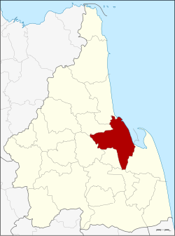
Amphoe Mueang Nakhon Si Thammarat
|
Mueang Nakhon Si Thammarat เมือง นครศรีธรรมราช |
|
|---|---|
| Province: | Nakhon Si Thammarat |
| Surface: | 617.4 km² |
| Residents: | 268,010 (2012) |
| Population density : | 429.1 U / km² |
| ZIP : | 80000, 80330, 80280, 80290 |
| Geocode : | 8001 |
| map | |

|
|
Mueang Nakhon Si Thammarat ( Thai : เมือง นครศรีธรรมราช ) the county is ( Amphoe - administrative district) of the provincial capital of the province of Nakhon Si Thammarat . The Nakhon Si Thammarat Province is located in the southern region of Thailand .
The capital of Mueang Nakhon Si Thammarat County is also called Nakhon Si Thammarat .
geography
The province of Nakhon Si Thammarat is located about 780 km south of Bangkok on the east coast of the Malay Peninsula to the Gulf of Thailand .
Adjacent areas (from the southeast clockwise) the Amphoe Pak Phanang , Chaloem Phra Kiat , Pra Prohm , Lan Saka , Phrom Khiri and Tha Sala . All Amphoe are in Nakhon Si Thammarat Province.
To the east lies the Gulf of Thailand .
traffic
Nakhon Si Thammarat Airport is located in this district .
education
The Rajabhat University of Nakhon Si Thammarat is located in Amphoe Mueang Nakhon Si Thammarat .
administration
Provincial Administration
The district of Nakhon Si Thammarat (Amphoe Mueang) is divided into 16 sub-districts ( tambon ) , which are further subdivided into 114 village communities ( Muban ) .
|
Note: The missing geocodes 9-11 and 17 belong to municipalities that were separated in 1994 to form the Amphoe Phra Phrom .
Local administration
Nakhon Si Thammarat ( เทศบาล นคร นครศรีธรรมราช ) is a large city ( Thesaban Nakhon ) in the district, it consists of the Tambon Nai Mueang, Tha Wang, Khlang, and parts of Na Khian and Pho Sadet.
Pak Phun ( เทศบาล เมือง ปาก พูน ) is a city ( Thesaban Mueang ) , it consists of parts of the Tambon Pak Phun.
There are also five small towns ( Thesaban Tambon ) in the district:
- Tha Phae ( เทศบาล ตำบล ท่าแพ ) consists of further parts of the Tambon Pak Phun,
- Bang Chak ( เทศบาล ตำบล บางจาก ) consists of the Tambon Bang Chak,
- Pak Nakhon ( เทศบาล ตำบล ปาก นคร ) consists of parts of the Tambon Tha Rai and Pak Nakhon.
- Tha Ngio ( เทศบาล ตำบล ท่า งิ้ว ) consists of the entire Tambon Tha Ngio,
- Pho Sadet ( เทศบาล ตำบล โพธิ์ เสด็จ ) consists of further parts of the Tambon Pho Sadet
There are also ten "Tambon Administration Organizations" (TAO, องค์การ บริหาร ส่วน ตำบล ) for the Tambon or the parts of Tambon in the county that do not belong to any town.
Individual evidence
- ↑ Population statistics 2012 . Department of Provincial Administration. Retrieved July 7, 2014.
Web links
Coordinates: 8 ° 25 ' N , 99 ° 58' E

