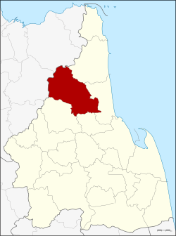
Amphoe Nopphitam
|
Noppitam น บ พิ ตำ |
|
|---|---|
| Province: | Nakhon Si Thammarat |
| Surface: | 720.156 km² |
| Residents: | 32,219 (2012) |
| Population density : | 41.2 U / km² |
| ZIP : | 80160 |
| Geocode : | 8021 |
| map | |

|
|
Amphoe Nopphitam ( Thai : อำเภอ น บ พิ ตำ ) is a district ( Amphoe - administrative district) in the north of the province of Nakhon Si Thammarat . The province of Nakhon Si Thammarat is located in southern Thailand , about 780 kilometers south of Bangkok on the east coast of the Malay Peninsula to the Gulf of Thailand .
geography
Neighboring districts (clockwise from northeast): the Amphoe Sichon , Tha Sala , Phrom Khiri and Phipun in the province of Nakhon Si Thammarat and the Amphoe Ban Na San and Kanchanadit in the province of Surat Thani .
The northern part of the Khao Luang National Park , which protects a large part of the Nakhon Si Thammarat mountain range , is also located in Nopphitam .
history
Nopphitam was initially set up as a subdistrict ( King Amphoe ) on April 1, 1995 , by separating four tambon from Amphoe Tha Sala .
On May 15, 2007 the Thai government decided to raise all 81 King Amphoe to simple amphoe status in order to unify the administration. With the publication in the Royal Gazette "Issue 124 chapter 46" on August 24, 2007 this decision officially entered into force.
administration
Provincial Administration
Amphoe Nopphitam is divided into four communities ( Tambon ) , which in turn are divided into 35 villages ( Muban ) .
|
Local administration
There is a small town ( Thesaban Tambon ) in the district:
- Na Reng ( เทศบาล ตำบล นา เห รง ) consists of the whole tambon Na Reng.
There are also three “tambon administration organizations” (TAO, องค์การ บริหาร ส่วน ตำบล ) for the tambon in the district that do not belong to any city.
Individual evidence
- ↑ ประกาศ กระทรวง มหาดไทย เรื่อง แบ่ง เขต ท้องที่ อำเภอ ท่าศาลา จังหวัด นครศรีธรรมราช ตั้ง เป็น กิ่ง อำเภอ น บ พิ ตำ . In: Royal Gazette . 112, No. 9 ง Special ( พิเศษ ), March 22, 2007, p. 53.
- ↑ www.manager.co.th
- ↑ พระราชกฤษฎีกา ตั้ง อำเภอ ฆ้องชัย ... และ อำเภอ เหล่า เสือ โก้ ก พ.ศ. ๒๕๕๐ Royal Gazette, Volume 124, Issue 46 ก of August 24, 2007, pp. 14-21 (in Thai)
- ↑ Population statistics 2012 . Department of Provincial Administration. Retrieved July 7, 2014.
Web links
Coordinates: 8 ° 43 ' N , 99 ° 45' E

