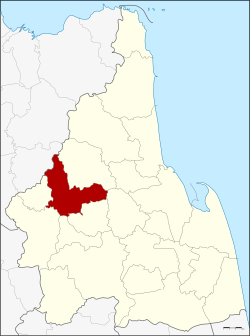
Chawang district
|
Chawang ฉวาง |
|
|---|---|
| Province: | Nakhon Si Thammarat |
| Surface: | 528.2 km² |
| Residents: | 67,021 (2012) |
| Population density : | 124.5 U / km² |
| ZIP : | 80150, 80250, 80260 |
| Geocode : | 8004 |
| map | |

|
|
Amphoe Chawang ( Thai : อำเภอ ฉวาง ) is a district ( amphoe - administrative district) in the province of Nakhon Si Thammarat . The province of Nakhon Si Thammarat is located in the southern region of Thailand about 780 km south of Bangkok on the east coast of the Malay Peninsula to the Gulf of Thailand .
geography
Neighboring districts (clockwise from northeast): Phipun , Lan Saka , Chang Klang , Na Bon , Thung Yai and Tham Phannara in Nakhon Si Thammarat and Wiang Sa in Surat Thani Province .
In the west of the district is the Khao Luang National Park .
administration
Provincial Administration
Amphoe Chawang is divided into ten communities ( Tambon ) , which in turn are divided into 84 villages ( Muban ) .
|
Note: the missing geocodes refer to the tambon that are now in Tham Phannara and Chang Klang.
Local administration
There are three small towns ( Thesaban Tambon ) in the county:
- Chan Di ( เทศบาล ตำบล จัน ดี ) consists of the entire tambon Chan Di.
- Chawang ( เทศบาล ตำบล ฉวาง ) consists of parts of the Tambon Chawang.
- Mai Riang ( เทศบาล ตำบล ไม้ เรียง ) consists of parts of the Tambon Mai Riang.
- Pak Nam Chawang ( เทศบาล ตำบล ปากน้ำ ฉวาง ) consists of further parts of the Tambon Chawang.
There are also eight “tambon administration organizations” (TAO, องค์การ บริหาร ส่วน ตำบล ) for the tambon or the parts of tambon in the county that do not belong to any town.
Individual evidence
- ↑ Population statistics 2012 . Department of Provincial Administration. Retrieved July 7, 2014.
Web links
Coordinates: 8 ° 26 ' N , 99 ° 30' E

