Lan Saka district
|
Lan Saka ลาน สกา |
|
|---|---|
| Province: | Nakhon Si Thammarat |
| Surface: | 342.90 km² |
| Residents: | 40,406 (2012) |
| Population density : | 116.8 U / km² |
| ZIP : | 80230 |
| Geocode : | 8003 |
| map | |

|
|
Amphoe Lan Saka ( Thai : อำเภอ ลาน สกา ) is a district ( Amphoe - administrative district) in the center of the Nakhon Si Thammarat province . The province of Nakhon Si Thammarat is located in the southern region of Thailand , about 780 km south of Bangkok on the east coast of the Malay Peninsula to the Gulf of Thailand .
geography
Neighboring districts (clockwise from north): Phrom Khiri Amphoe , Mueang Nakhon Si Thammarat , Phra Phrom , Ron Phibun , Thung Song , Chang Klang , Chawang and Phipun . All Amphoe are in Nakhon Si Thammarat Province.
The National Park Khao Luang is situated in the district of Lan Saka.
history
Lan Saka was initially a subdistrict ( King Amphoe ) called Khao Kaeo ( เขา แก้ว ), which was subordinate to Mueang Nakhon Si Thammarat . When the administration was moved to Tambon Lan Saka, the district was renamed accordingly. In 1958, Lan Saka was promoted to Amphoe.
There is a ruin in Amphoe Lan Saka called "Taksin's Palace". According to a popular legend, King Taksin (r. 1767–82) is said to have lived here after his deposition and alleged execution (in which, according to this story, someone else died in his place).
administration
Provincial Administration
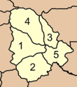
Amphoe Lan Saka is divided into five communities ( tambon ) , which in turn are divided into 42 villages ( muban ) .
|
Local administration
There are two small towns ( Thesaban Tambon ) in the county:
- Lan Saka ( เทศบาล ตำบล ลาน สกา ) consists of parts of the Tambon Khao Kaeo.
- Khun Thale ( เทศบาล ตำบล ขุน ทะเล ) consists of the entire Tambon Khun Thale
There are also four "Tambon Administration Organizations" (TAO, องค์การ บริหาร ส่วน ตำบล ) for the Tambon or the parts of Tambon in the county that do not belong to any town.
Individual evidence
- ↑ lansaka.nakhoncdp.go.th - History of the City of Lan Saka ( Memento of the original from January 3, 2007 in the Internet Archive ) Info: The archive link was inserted automatically and has not yet been checked. Please check the original and archive link according to the instructions and then remove this notice. (in Thai)
- ^ BJ Terwiel : Thailand's Political History. From the Fall of Ayutthaya to Recent Times. River Books, Bangkok 2005, ISBN 974-9863-08-9 , p. 60.
- ↑ Population statistics 2012 . Department of Provincial Administration. Retrieved July 7, 2014.
Web links
- More details on Lan Saka from amphoe.com (in Thai)
- Lan Saka City Website (in Thai)
- Information on Khao Luang National Park (in English)
Coordinates: 8 ° 22 ' N , 99 ° 48' E

