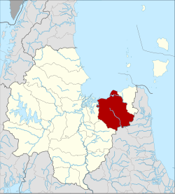
Amphoe Kanchanadit
|
Kanchanadit กาญจนดิษฐ์ |
|
|---|---|
| Province: | Surat Thani |
| Surface: | 879.0 km² |
| Residents: | 102,179 (2012) |
| Population density : | 112.0 U / km² |
| ZIP : | 84160, 84290 |
| Geocode : | 8402 |
| map | |

|
|
Amphoe Kanchanadit ( Thai : อำเภอ กาญจนดิษฐ์ ) is a district ( Amphoe - administrative district) in the east of Surat Thani Province . The Surat Thani Province is located in the southern region of Thailand .
geography
The district is located in the eastern part of the province. It extends from the coast of Ban Don Bay in the Gulf of Thailand in the north over the Maenam Tapi river valley to the Nakhon Si Thammarat mountain range in the west and south. The Tai Rom Yen National Park , which was established on December 31, 1991, is also located here. The largest river in the district is the Maenam Thathong ( แม่น้ำ ท่า ทอง ), which flows into the Tapi near the provincial capital.
Neighboring districts are (from the east clockwise) Don Sak District in the province of Surat Thani, the two Amphoe Sichon and Nopphitam the province of Nakhon Si Thammarat and the Ban Na San District and Mueang Surat Thani again in the province of Surat Thani. In the north lies the Gulf of Thailand .
traffic
The main roads connecting the district are:
- the "National Road 401" ( ทางหลวง แผ่นดิน หมายเลข ๔๐๑ ) - it connects the province of Phang Nga with the province of Nakhon Si Thammarat ,
- the “National Road 44” ( ทางหลวง แผ่นดิน หมายเลข ๔๔ ) - it runs from the junction with “Route 401” in Surat Thani to the southwest across the Malay Peninsula to Krabi Province .
history
Originally the city was called Thathong ( ท่า ทอง ) and was located on Khlong Thathong Mai ( คลอง ท่า ทอง ใหม่ - at that time it was still called Khlong Tha Phechon - คลอง ท่าเพชร). Since the city was heavily contaminated with malaria, it was relocated to its present location during the reign of King Phra Nang Klao ( Rama III ) and renamed Kanchanadit. It was a provincial city ( mueang ) under the control of the kingdom of Nakhon Si Thammarat . In 1899 the city was merged with Chaiya and became an amphoe.
Attractions
- Training center for monkeys - Seven kilometers east of the provincial capital Surat Thani is a school for macaques , who are trained for three months to harvest coconuts . This school was established in 1957 by Somporn Saekow (1940 - August 20, 2002, Thai สม พร แซ่ โค้ ว ) on the advice of his Buddhist teacher Buddhadasa Bhikkhu . Since it is illegal to catch and train wild monkeys in Thailand, many farmers brought monkeys of their own breed to this school to be trained here. The school became so famous throughout Thailand over the years that Somporn and his favorite monkey Khai Nui were allowed to carry the provincial flag at the National Games in 1963. Somporn died of a heart attack in 2002, but his family continues to run his school.
administration
Provincial Administration
Amphoe Kanchanadit is divided into 13 communities ( Tambon ) , which are further divided into 117 villages ( Muban ) .
|
Local administration
There are five small towns ( Thesaban Tambon ) in the county:
- Kanchanadit ( เทศบาล ตำบล กาญจนดิษฐ์ ) consists of the entire Tambon Ka Dae,
- Tha Thong Mai ( เทศบาล ตำบล ท่า ทอง ใหม่ ) consists of parts of the Tambon Tha Thong Mai,
- Chang Sai ( เทศบาล ตำบล ช้าง ซ้าย ) consists of the entire tambon Chang Sai,
- Chang Khwa ( เทศบาล ตำบล ช้าง ขวา ) consists of the entire tambon Chang Khwa,
- Krut ( เทศบาล ตำบล กรูด ) consists of the entire Tambon Krut.
There are also nine "Tambon Administrative Organizations " ( องค์การ บริหาร ส่วน ตำบล - Tambon Administrative Organizations, TAO) for the Tambon or the parts of Tambon in the county that do not belong to any city.
Individual evidence
- ↑ Population statistics 2012 . Department of Provincial Administration. Retrieved July 13, 2014.
Web links
Coordinates: 9 ° 10 ' N , 99 ° 28' E


