Amphoe Tha Chang (Surat Thani)
|
Tha Chang ท่าฉาง |
|
|---|---|
| Province: | Surat Thani |
| Surface: | 1,167.7 km² |
| Residents: | 32,902 (2012) |
| Population density : | 24.8 U / km² |
| ZIP : | 84150 |
| Geocode : | 8411 |
| map | |

|
|
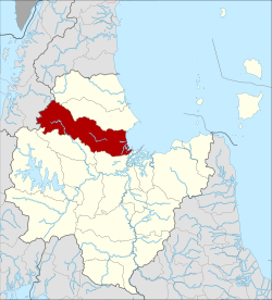
Amphoe Tha Chang ( Thai อำเภอ ท่าฉาง ) is a district ( Amphoe - Administrative District) in Surat Thani Province . The Surat Thani Province is located in the southern region of Thailand .
geography
The neighboring amphoe and areas are (clockwise from north): Chaiya in the north, Bandon Bay in the east, Phunphin , Vibhavadi and Ban Ta Khun in the south, in the west lies the Kapoe district of Ranong province .
The district stretches from the coast to Bandon Bay in the east to the Phuket mountain range, on which the border between the provinces of Surat Thani and Ranong runs. The Kaeng Krung National Park is located in these mountains.
By the district both the south line of the Thai railway runs ( State Railway of Thailand ) and the Asian Highway AH2 .
history
Tha Chang was initially set up as a subdistrict ( King Amphoe ) on July 31, 1908 , consisting of the Tambon Than, Pak Chalui and Sawiat from Amphoe Phum Riang and the Tambon Tha Khoei, Tha Chang and Khlong Sai of Amphoe Phunphin. The subdistrict was subordinate to Phum Riang. On August 1, 1938, Tha Chang was promoted to Amphoe.
administration
Provincial Administration
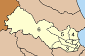
The Amphoe Tha Chang is divided into 6 subdistricts ( tambon ) , which in turn have a total of 46 communities ( muban ) .
|
Local administration
Tha Chang ( เทศบาล ตำบล ท่าฉาง ) is a small town ( Thesaban Tambon ) in the district, it consists of parts of the Tambon Tha Chang and Khao Than.
There are also six "Tambon Administrative Organizations " ( องค์การ บริหาร ส่วน ตำบล - Tambon Administrative Organizations, TAO) for the Tambon or the parts of Tambon in the district that do not belong to any city.
Individual evidence
- ↑ แจ้ง ความ กระทรวง มหาดไทย . In: Royal Gazette . 25, No. 19, August 9 1908, p. 569.
- ↑ ประกาศ สำนัก นายกรัฐมนตรี เรื่อง ยก ฐานะ กิ่ง อำเภอ ท่าฉาง เป็น อำเภอ และ ยุบ อำเภอ พระแสง ลง เป็น กิ่ง อำเภอ . In: Royal Gazette . 55, No. 0 ง , August 1 1938, pp. 1321-1322.
- ↑ Population statistics 2012 . Department of Provincial Administration. Retrieved July 13, 2014.
Web links
Coordinates: 9 ° 17 ' N , 99 ° 12' E

