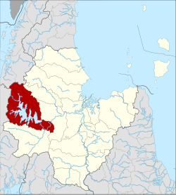
Ban Ta Khun district
|
Ban Ta Khun บ้านตาขุน |
|
|---|---|
| Province: | Surat Thani |
| Surface: | 1308.2 km² |
| Residents: | 15,745 (2012) |
| Population density : | 10.8 U / km² |
| ZIP : | 84230 |
| Geocode : | 8409 |
| map | |

|
|
Amphoe Ban Ta Khun ( Thai : อำเภอ บ้านตาขุน ) is a district ( Amphoe - administrative district) in the west of Surat Thani Province . The Surat Thani Province is located in the southern region of Thailand .
Amphoe Ban Ta Khun is both the largest district in terms of area in the province, but also has the lowest population density.
geography
The district is largely located in the Phuket mountain range. Parts of the district are protected by the Khao Sok National Park . The Khlong Saeng Wildlife Sanctuary , which is mainly located in Ranong Province, occupies a small part of the north-west of the county.
The Saeng Canal ( Khlong Saeng) is the largest river in the county. He is from the dam Rajjaprabha to Cheow Lan Lake dammed. It flows into the Phum Duang River near the city of Khao Wong.
The neighboring amphoe and areas are (clockwise from the north): Tha Chang , Vibhavadi , Khiri Rat Nikhom and Phanom amphoe in Surat Thani Province. In the west is Amphoe Khura Buri of Phang Nga Province and in the northwest the Amphoe Suk Samran and Kapoe of Ranong Province .
history
The district was established as a subdistrict ( King Amphoe ) on July 20, 1973 by separating five tambon from the Amphoe Khiri Council Nikhom . The fifth tambon Krai Son ( ไกรสร ) was later merged with Tambon Khao Phang. On September 9, 1976, he was granted full Amphoe status.
Administrative units
Provincial Administration
The Amphoe Ban Ta Khun is divided into four subdistricts ( tambon ) , these in turn have a total of 29 communities ( muban ) .
| No. | Surname | Thai | Muban | Pop. |
|---|---|---|---|---|
| 1. | Khao Wong | เขาวง | 6th | 5.105 |
| 2. | Pha Saeng | พะ แสง | 9 | 3,467 |
| 3. | Phru Thai | พรุ ไทย | 9 | 2,722 |
| 4th | Khao Phang | เขา พัง | 5 | 4,451 |
Local administration
There are two small towns ( Thesaban Tambon ) in the county:
- Ban Takhun ( เทศบาล ตำบล บ้านตาขุน ) consists of parts of the Tambon Khao Wong,
- Chiao Lan ( เทศบาล ตำบล บ้าน เชี่ยว หลาน ) consists of parts of the Tambon Khao Phang.
There are also three “tambon administration organizations” (TAO, องค์การ บริหาร ส่วน ตำบล ) for the tambon or the parts of tambon in the district that do not belong to any city.
Individual evidence
- ↑ ประกาศ กระทรวง มหาดไทย เรื่อง แบ่ง ท้องที่ อำเภอ คีรีรัฐนิคม จังหวัด สุราษฎร์ธานี ตั้ง เป็น กิ่ง อำเภอ บ้านตาขุน Royal Gazette, Vol. 90, Ed. 86 ง , July 17, 1973, p. 2153 (in Thai)
- ↑ พระราชกฤษฎีกา ตั้ง อำเภอ เลาขวัญ อำเภอ คำม่วง อำเภอ พิปูน อำเภอ ศรีเทพ อำเภอ นาแห้ว อำเภอ ส่องดาว อำเภอ ควนกาหลง อำเภอ ค่ายบางระจัน อำเภอ บ้านตาขุน และ อำเภอ กุดจับ พ.ศ. ๒๕๑๙ Royal Gazette, Vol. 93, Ed. 109 ก special ( ฉบับ พิเศษ ) of September 8, 1976, pp. 31–34 (in Thai)
- ↑ Population statistics 2012 . Department of Provincial Administration. Retrieved July 13, 2014.
Web links
Coordinates: 8 ° 54 ' N , 98 ° 53' E

