Chai Buri district
|
Tha Chana ชัย บุรี |
|
|---|---|
| Province: | Surat Thani |
| Surface: | 440.7 km² |
| Residents: | 26,409 (2012) |
| Population density : | 53.0 U / km² |
| ZIP : | 84350 |
| Geocode : | 8418 |
| map | |

|
|
Amphoe Chai Buri ( Thai : อำเภอ ชัย บุรี ) is a district ( Amphoe - administrative district) in the south of Surat Thani Province . The Surat Thani Province is located in the southern region of Thailand .
geography
The neighboring Amphoe are Amphoe Phrasaeng in the north and east, Amphoe Khao Phanom ( Krabi Province ) in the south and Amphoe Plai Phraya (also Krabi) in the west.
The main water resource is the Khlong Thorom ( คลอง โต รม ), which flows through the district from south to north.
The Khlong Phraya Game Reserve ("Khlong Phraya Wildlife Sanctuary") is located on the border with the Plai Phraya district.
history
The district of Chai Buri was initially set up as a subdistrict ( King Amphoe ) on June 5, 1981 , by separating the Tambon Song Phraek and Chai Buri from the Phrasaeng district. The name Chai Buri was chosen in honor of the first administrative officer of Phrasaeng Khun Chai Buri.
The subdistrict began its work on September 10, 1981, the office initially served as a viharn in Wat Samai Suwan, Tambon Song Phraek. The first head of the subdistrict was Wisut Tansutthiwanit. In 1983 the Ministry of the Interior selected two lots for the new administration building, one in Tambon Song Phraek and one in Tambon Chai Buri. However, since the first property tended to be flooded and it was not in the center of the district, the second property was selected on the recommendation of Napha Kanchonkirana, the head of the sub-district. In July 1984 the new administration building was inaugurated.
On July 4, 1994, the sub-district officially got full amphoe status.
administration
Provincial Administration
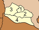
The Amphoe Chai Buri is divided into four subdistricts ( tambon ) , which in turn have a total of 37 communities ( muban ) .
|
Local administration
There are no cities ( thesaban ) in the district. Each of the four tambon is administered by a tambon administrative organization ("Tambon Administrative Organization" - TAO, Thai: องค์การ บริหาร ส่วน ตำบล ).
Individual evidence
- ↑ ประกาศ กระทรวง มหาดไทย เรื่อง แบ่ง ท้องที่ อำเภอ พระแสง จังหวัด สุราษฎร์ธานี ตั้ง เป็น กิ่ง อำเภอ ชัย บุรี Royal Gazette, Volume 94, Issue 42 ง of March 17, 1981, p. 754 (in Thai)
- ↑ พระราชกฤษฎีกา ตั้ง อำเภอ เปือยน้อย ... และ อำเภอ ศรีวิไล พ.ศ. ๒๕๓๗ Royal Gazette, Vol. 111, Ed. 21 ก June 3, 1994, pp. 32–35 (in Thai)
- ↑ Population statistics 2012 . Department of Provincial Administration. Retrieved July 13, 2014.
Web links
Coordinates: 8 ° 28 ' N , 99 ° 5' E

