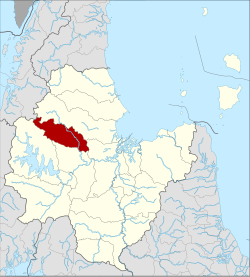
Amphoe Vibhavadi
|
Vibhavadi วิภาวดี |
|
|---|---|
| Province: | Surat Thani |
| Surface: | 543.5 km² |
| Residents: | 14,989 (2012) |
| Population density : | 23.4 U / km² |
| ZIP : | 84180 |
| Geocode : | 8419 |
| map | |

|
|
Amphoe Vibhavadi ( Thai : อำเภอ วิภาวดี ) is a district ( Amphoe - administrative district) in the west of Surat Thani Province . The Surat Thani Province is located in the southern region of Thailand .
geography
In the district lies the Phuket mountain range. Part of the district is protected by the Khlong Yan Wildlife Sanctuary and the Kaeng Krung National Park.
The neighboring amphoe and areas are (clockwise from north): Tha Chang , Phunphin , Khiri Rat Nikhom and Ban Ta Khun .
history
Vibhavadi was established as a sub-district ( King Amphoe ) on April 1, 1992 , by separating two tambon of the Khiri Rat Nikhom district . It was named after Princess Vibhavadi Rangsit, who was killed in 1977 by rebels in eastern Surat Thani Province.
On August 24, 2007, Vibhavadi was promoted to a full district along with all of the other 81 sub-districts of Thailand.
Well-known temples
There are three Buddhist temples ( Wat ) in the Vibhavadi district , all of which belong to the Mahayana community.
- Wat Pho Noi ( วัด โพธิ์ น้อย )
- Wat Aran Ya Ram ( วัด อรัญ ญา ราม )
- Wat Vibhavadi Wana Ram ( วัด วิภาวดี วนาราม )
administration
Provincial Administration
The district of Vibhavadi is divided into two municipalities ( tambon ) , which in turn have a total of 31 municipalities ( muban ) .
|
Local administration
Each of the two tambon is administered by a " Tambon Administrative Organization " ( องค์การ บริหาร ส่วน ตำบล - Tambon Administrative Organization, TAO).
Individual evidence
- ↑ ประกาศ กระทรวง มหาดไทย เรื่อง แบ่ง เขต ท้องที่ อำเภอ คีรีรัฐนิคม จังหวัด สุราษฎร์ธานี ตั้ง เป็น กิ่ง อำเภอ วิภาวดี Royal Gazette, Vol. 109, Issue 53 ง special ( ฉบับ พิเศษ ) of April 22, 1992, p. 19 (in Thai)
- ↑ พระราชกฤษฎีกา ตั้ง อำเภอ ฆ้องชัย ... และ อำเภอ เหล่า เสือ โก้ ก พ.ศ. ๒๕๕๐ Royal Gazette, Vol. 124, Ed. 46 ก , August 24, 2007, pp. 14-21 (in Thai)
- ↑ Population statistics 2012 . Department of Provincial Administration. Retrieved July 13, 2014.
Web links
Coordinates: 9 ° 14 ' N , 98 ° 59' E

